INI ADALAH CONTOH BUKU ELEKTRONIK DALAM CD-ROM KREASI Dr IWAN TANPA ILLUSTRASI
THIS IS THE SAMPLE OF Dr IWAN CD-ROM E-BOOK WITHOUT ILLUSTRATIONS
THE COMPLETE CD WITH ILLUSTRATION EXIST,TO GET IT PLEASE SUBSCRIBED VIA COMMENT WITH UPLOAD YOUR ID COPY.
On January 15, 1493,

he set sail for home by way of the Azores. To achieve that goal, “He wrestled his ship against the wind and ran into a fierce storm.”
Leaving the island of Santa Maria in the Azores, Columbus headed for Spain, but another storm forced him into Lisbon.
He anchored next to the King’s harbor patrol ship on March 4, 1493, where he was told a fleet of 100 caravels had been lost in the storm.
Astoundingly, both the Niña and the Pinta were spared. Not finding the King John in Lisbon, Columbus wrote a letter to him and waited for the king’s reply. The king requested that Columbus go to Vale do Paraíso to meet with him. Some have speculated that his landing in Portugal was intentional.
Relations between Portugal and Castile were poor at the time. Columbus went to meet with the king at Vale do Paraíso (north of Lisbon). After spending more than one week in Portugal, he set sail for Spain. Word of his finding new lands rapidly spread throughout Europe. He reached Spain on March 15.
He was received as a hero in Spain. He displayed several kidnapped natives and what gold he had found to the court, as well as the previously unknown tobacco plant, the pineapple fruit, the turkey and the sailor’s first love, the hammock. He did not bring any of the coveted East Indies spices, such as the exceedingly expensive black pepper, ginger or cloves. In his log, he wrote “there is also plenty of ají, which is their pepper, which is more valuable than black pepper, and all the people eat nothing else, it being very wholesome” (Turner, 2004, P11). The word ají is still used in South American Spanish for chili peppers.
Columbus’s report to the royal court in Madrid was extravagant. He insisted he had reached Asia (it was Cuba) and an island off the coast of China (Hispaniola). His descriptions were part fact, part fiction: “Hispaniola is a miracle. Mountains and hills, plains and pastures, are both fertile and beautiful…the harbors are unbelievably good and there are many wide rivers of which the majority contain gold…There are many spices, and great mines of gold and other metals…”.
In his first journey, Columbus visited San Salvador in the Bahamas (which he was convinced was Japan), Cuba (which he thought was China) and Haiti (where he found gold).
But still discontent was growing. Gradually the minds of the men were becoming diseased through terror, even the calmness of the weather increasing their fears, for with such light winds, and from the east, too, how were they ever to get back? However, as if to allay their feelings, the wind soon shifted to the southwest.
A little after sunset on the 25th, Columbus and his officers were examining their charts and discussing the probable location of the island Cipango,* which the admiral had placed on his map, when from the deck of the Pinta arose the cry of ” Land ! Land ! ” At once Columbus fell on his knees and gave thanks to Heaven. Martin Alonzo and his crew of the Pinta broke out into the Gloria in Excelsis,” in which the crew of the Santa Maria joined, while the men of the Nina scrambled up to the masthead and declared that they, too, saw land.
At once Columbus ordered the course of the vessels to be changed toward the supposed land. In impatience the men waited for the dawn, and when the morning appeared, lo ! the insubstantial pageant had faded, the cloud vision, for such it was, had vanished into thin air. The disappointment was as keen as the enthusiasm had been intense; silently they obeyed the admiral’s order, and turned the prows of their vessels to the west again.
* Cipango was an imaginative island based upon the incorrect cosmography of Toscanelli, whose map was accepted in Columbus’s time as the most nearly correct chart of any extant. The Ptolemaic theory of 20,400 geographical miles as the Equatorial girth was accepted by Columbus, which lessened his degrees of latitude and shortened the distance he would have to sail to reach Asia. The island Cipango was supposed to be over 1000 miles long, running north and south, and the distance placed at 52 degrees instead of the 230 degrees which actually separates the coast of Spain from the eastern coast of Asia. The island was placed in about the latitude of the Gulf of Mexico.
A week passed, marked by further variations of the needle and flights of birds. The first day of October dawned with such amber weather as is common on the Atlantic coast in the month of “mists and yellow fruitfulness.” The pilot on Columbus’s ship announced sorrowfully that they were then 520 leagues, or 1560 miles, from Ferro. He and the crew were little aware that they had accomplished 707 leagues, or nearly 2200 miles. And Columbus had a strong incentive for this deception; for, had he not often told them that the length of his voyage would be 700 leagues? and had they known that this distance had already been made, what might they not have done! On the 7th of October the Nina gave the signal for land, but instead of land, as they advanced the vision melted and their hopes were again dissipated.
The ship had now made 750 leagues and no land appeared. Possibly he had made a mistake in his latitude; and so it was that, observing birds flying to the southward, Columbus changed his course and followed the birds, recalling, as he says in his journal, that by following the flight of birds going to their nesting and feeding grounds the Portuguese had been so successful in their discoveries. On Monday, the 8th, the sea was calm, with fish sporting everywhere in great abundance; flocks of birds and wild ducks passed by. Tuesday and Wednesday there was a continual passage of birds.
On the evening of this day, while the vessels were sailing close together, mutiny suddenly broke out. The men could trust to signs no longer. With cursing and imprecation they declared they would not run on to destruction, and insisted upon returning to Spain. Then Columbus showed the stuff he was made of. He and they, he said, were there to obey the commands of their Sovereigns; they must find the Indies. With unruffled calmness he ordered the voyage continued.
On Thursday, the 11th, the spirit of mutiny gave way to a very different feeling, for the signs of the nearness of land multiplied rapidly. They saw a green fish known to feed on the rocks, then a branch with berries on it, evidently recently separated from a tree, floated by them, and above all, a rudely carved staff was seen. Once more gloom and mutiny gave way to sanguine expectation. All the indications pointing to land in the evening, the ships stood to the west, and Columbus, assembling his men, addressed them. He thought land might be made that night, and enjoined that a vigilant lookout be kept, and ordered a double watch set. He promised a silken doublet, in addition to the pension guaranteed by the Crown, to the one first seeing land
Columbus Reaches the New World
The first sight of the new world – Columbus discovering America
The morning light came, and, lifting the veil that had concealed the supreme object of their hopes, revealed a low, beautiful island, not fifty miles long, and scarcely two leagues away. Columbus gave the signal to cast anchor and lower the boats, the men to carry arms. Dressed in a rich costume of scarlet, and bearing the royal standard, upon which was painted the image of the crucified Christ, he took the lead, followed by the other captains, Pinzon and Yanez. Columbus was the first to land; and as soon as he touched the shore he fell down upon his knees and fervently kissed the blessed ground ” three times, returning thanks to God for the great favor bestowed upon him. The others followed his example; and then, recognizing the Providence which had crowned his efforts with success, he gave the name of the Redeemer San Salvador to the discovered island, which was called by the natives ” Guanahani.” * And now the crews, who but a few days previously had reviled and cursed Columbus, gathered around, asking pardon for their conduct and promising complete submission in future.
* It is simply impossible to say which one of that long stretch of islands, some 3000 in number, extending from the coast of Florida to Haiti, as if forming a breakwater for the island of Cuba, Guanahani is. Opinion greatly varies. San Salvador, or Cat Island, was in early favor Humboldt and Irving the latter having the problem worked out for him by Captain A. S. Mackenzie, U. S. N. favored that view. The objections are that it is not “a small island ” as Columbus called it, and it does not answer to the description of having “a vast lake in the middle” as Columbus says of Guanahani in his journal. Navette advocates the Grand Turk Island which has the lake. Watling’s Island was first advocated by Munoz and accepted by Captain Beecher, R. N., in 1856, and Oscar Perchel in 1858. Major, of the British Museum, has taken up with Watling’s Island, as did Lieutenant J. B. Murdoch, U. S. N., after a careful examination in 1884. This view is accepted by C. A. Schott of the U. S. Coast Survey. On the other hand, Captain G. V. Fox, U. S. N., in 1880, put forth an elaborate claim for Samana, based upon a very careful examination of the route as given in Columbus’s journal. This claim, with careful consideration of other conditions, has been very carefully examined by Mr. Charles H. Rockwell, an astronomer, of Tarrytown, N. Y. Mr. Rockwell assents to Captain Fox’s view, which he finds confirmed by the course Columbus took in bringing his ship to land. He also traverses Captain Beecher’s claim for Watling’s Island, which he finds to be inconsistent with Columbus’s narrative. As we have said, the problem is beset with difficulties, both as relates to the sailing course, and the extent and topography of the island ; and at the present time it appears to be well nigh insoluble. Where the external conditions are met, the internal conditions, including the large lake, seem wanting ; the difficulties in the case seem to be irresistible.
Columbus supposed at last he had reached the opulent land of the Indies, and so called the natives Indians. But it was an island, not a continent or an Asiatic empire, he had found; an island very large and level, clad with the freshest trees, with much water in it, a vast lake in the middle, and no mountains.”
Likely Origins of the Legend
According to tradition, the natives of Hispaniola, Puerto Rico and Cuba told the early Spanish explorers that in Bimini (Beniny), a land to the north, there was a river, spring or fountain where waters had such miraculous curative powers that any old person who bathed in them would regain his youth. About the time of Columbus’s first voyage, says the legend, an Arawak chief named Sequene, inspired by the fable of the curative waters, had migrated from Cuba to southern Florida. It seems that other parties of islanders had made attempts to find Bimini, which was generally described as being in the region of the Bahamas.
Juan Ponce de Leon (1460-1521), who had been with Columbus on his second voyage in 1493 and who had later conquered and become governor of Puerto Rico, is supposed to have learned of the fable from the Indians. The fable was not new, and probably Pence de Leon was vaguely cognizant of the fact that such waters had been mentioned by medieval writers, and that Alexander the Great had searched for such waters in eastern Asia. A similar legend was known to the Polynesians, whose tradition located the fountain of perpetual youth in Hawaii.
As described to the Spanish, Bimini not only contained a spring of perpetual youth but teemed with gold and all sorts of riches. The fact that the party of Arawaks who had gone in that direction had never returned was taken as evidence that they must have found the happy land!
In that age of discovery, when new wonders and novelties were disclosed every year, not only the Spanish explorers but also men of learning accepted such stories with childlike credulity. Pietro Martire d’Anghiera (1472-1528), an Italian geographer and historian who moved to Spain in 1487 and who is known as “Peter Martyr” wrote to Pope Leo X in 1513: “Among the islands of the north side of Hispaniola, there is about 325 leagues distant, as they say who have searched the same, in which is a continual spring of running water, of such marvelous virtue that the water thereof being drunk, perhaps with some diet, maketh old men young again.” The chronicler himself discounted the tale, but he told his Holiness that “they have so spread this rumor for a truth through all the court, that not only all the people, but also many of them whom wisdom or fortune hath divided from the common sort, think it to be true.”
Ponce de Leon, who had become wealthy in the colonial service, equipped three ships at his own expense and set out to find the land of riches and perhaps the mythical fountain that would restore his health and make him young again. It is a common, mistake to suppose that he was then an old man. He was only about fifty-three.
Ponce de Leon, like most of the other early Spanish explorers and conquerors, was looking primarily for gold, slaves and other “riches,” and it is not likely that he actually put much stock in the fable of the fountain of youth, if he had heard about it at all.
That fable was not associated with de Leon’s name until long afterwards, when Hernando de Escaiante de Fontaneda told it in his account of Florida. In 1545 Fontaneda, at the age of thirteen, was shipwrecked on the coast of Florida and spent seventeen years as a captive of the Indians. He was finally rescued, probably by the French in northeastern Florida, and later returned to the peninsula as an interpreter for Menendez in 1565. Antonio de Herrera y Tordesilias (1540?-1625) had access to Fontaneda’s manuscript and incorporated the story in his history of the Indies.
Whether any Europeans had visited Florida before Ponce de Leon’s first expedition is not known for certain. Some authorities suppose that both John Cabot and Amerigo Vespucci had explored and mapped part of the coast. At any rate, Alberto Cantino’s Spanish map of 1502 indicated a peninsula corresponding to Florida.
On March 27, 1513 (not 1512 as often stated), after searching vainly for Bimini among the Bahamas, Ponce de Leon sighted the North American mainland, which he took to be an island, and on April 2 he landed somewhere on the eastern coast. Nobody knows for certain where he first set foot on Florida soil. Some suppose that it was north of St. Augustine, while others think it was as far south as Cape Canav- eral. Either because the discovery was made during the Easter season, or because he found flowers on the coast, or for both reasons, he named the country La Florida. In Spanish, Easter Sunday is la pascua florida, literally “the flowery passover.” “And thinking that this land was an island they named it La Florida because they discovered it in the time of the flowery festival.”
From a book about American history called A Book About American History, by George Stimpson
|
Voyages and Dates
|
Men and Supplies
|
Area Explored
|
|
First Expedition 1492-1493
|
3 ships
|
Bahamas, Hispaniola, Cuba
|
|
Second Expedition 1493-1496
|
17 ships, 1,500 colonists
|
Cuba, Leeward Is., Puerto Rico
|
|
Third Expedition 1498-1500
|
convicts
|
Trinidad, Venezuela
|
|
Fourth Expedition 1502
|
4 ships
|
Honduras, marooned in Jamaica
|
Columbus enslaved around 2000 Taino and in 1495 when his demands for gold did not satisfy, he waged all out war “with God’s aid soon gained complete victory, killing many Indians and capturing others who were also killed”. Columbus was never really satisfied with the Caribbean Indians who had relatively small amounts of gold. After his fourth voyage Columbus died in relative obscurity. The precedence for the treatment of Native peoples had been set and each time Spanish reached new native people they were under orders to read the requerimiento and if they did not swear allegiance to the Pope and Spanish Crown.
” I certify to you that, with the help of God, we shall powerfully enter into your country and shall make war against you in all ways and manners that we can, and shall subject you to the yoke and obedience of the Church and of Their Highnesses. We shall take you and your wives and your children and shall make slaves of them, and as such shall sell and dispose of as them as Their Highnesses may command. And we shall take your goods, and shall do all the mischief and damage that we can, as to vassals who do not obey and refuse to receive their lord and resist and contradict him”
In most cases the Indians were not provided with translations and the Spanish did what they wanted. However, Spanish treatment of Indians was backfiring since the colonies in Hispaniola and Cuba were decimating Indian labor the temptation of the mainland of MesoAmerica became overwhelming. Although, Columbus was not rewarded in Spain he was made a legend in America and initiated what has been referred to as the Columbian Exchange.
Columbus Landing in the New World
The natives dwelling on the island were found to be a well proportioned people with fine bodies, simple in their habits and customs, friendly, though shy in manner, and they were perfectly naked. They thought the huge ships to be monsters risen from the sea or gods come down from heaven. Presents were exchanged with them, including gold bracelets worn by the natives. Inquiry was made as to where the gold came from. For answer the natives pointed by gestures to the southwest
. Columbus tried to induce some of the natives to go with him and show where the land of gold was to be found. But this they refused to do; so on the next day (Sunday, the 14th), taking along by force seven natives, that he might instruct them in Spanish and make interpreters of them, he set sail to discover, if possible, where gold was to be had in such abundance, and which, he thought, must be Cipango.
He was, of course, in the midst of the Bahama group, and did not have to sail far to discover an island.
On the 15th
he discovered the island Conception. On the third day he repeated the forms of landing and took possession, as he did
also on the 16th,
when he discovered an island which he called Fernandina, known to be the island at present called Exuma.
On the 19th
another island was discovered, which Columbus named Isabella, and which he declared to be ” the most beautiful of all the islands ” he had seen. The breezes brought odors as spicy as those from Araby the Blest; palm trees waved their fringed banners to the wind, and flocks of parrots obscured the sky. It was a land where every prospect pleased.
But no it was not a land of gold. Leaving Isabella after a five days’ sojourn,
on Friday, the 26th of October,
he entered the mouth of a beautiful river on the northeast terminus of the island of Cuba, where sky and sea seem to conspire to produce endless halcyon days, for the air was a continual balm and the sea bathes the grasses, which grow to the water’s edge, whose tendrils and roots are undisturbed by the sweep of the tides.
Upon the delights that came to Columbus in this new found paradise we cannot dwell; admiration and rapture mingled with the sensations that swept over the soul of the great navigator as he contemplated the virgin charms of a new world won by his valor.But the survey of succeeding events must be rapid.
From the 28th of October till November 12th
Columbus explored the island, skirting the shore in a westerly direction. He discovered during that time tobacco, of which he thought little, but which, singularly enough, proved more productive to the Spanish Crown than the gold which he sought but did not find.
On the 20th of November
Columbus was deserted by Martin Pinzon, whose ship, the Pinta, could outsail all the others. Martin would find gold for himself. This was a kind of treachery which too often marred the story of Spanish exploration in the New World.
For two weeks after the Pinta’s desertion
Columbus skirted slowly along the coast of Cuba eastwardly till he doubled the cape. Had he only kept on what was now a westerly course he would have discovered Mexico. But it was not to be.
Before sailing he lured on board six men, seven women, and three children, a proceeding which nothing can justify.
Taking a southwesterly course, on Wednesday, December 5th, Columbus discovered Haiti and San Domingo, which he called Hispaniola, or Little Spain. The next day he discovered the island Tortuga, and at once returned to Haiti, exploring the island; there, owing to disobedience of orders, on Christmas morning, between midnight and dawn, the Santa Maria was wrecked upon a sand bank, near the present site of Port au Paix. A sorry Christmas for Columbus, indeed !
The situation was now critical. The Pinta, with her mutinous commander and crew, was gone; the Santa Maria was a wreck. But one little vessel remained, the little, undecked Nina. Suppose she should be lost, too? how would Spain ever know of his grand discoveries? Two things were necessary: he must at once set out on his return voyage, and some men must be left behind. The first thing he did was to build, on a bay now known as Caracola, a fort, using the timbers of the wrecked Santa Maria. In this he placed thirty nine men. Nature would surely give them all the shelter and provisions they needed.
David Reed, dreed@flmnh.ufl.edu, New study blames Columbus for syphilis spread
The Lost Fort of Columbus
On his voyage to the Americas in 1492, the explorer built a small fort somewhere in the Caribbean. A construction contractor from Washington State has spent decades trying to find it.
By Frances Maclean
Photographs by Les Stone
Smithsonian magazine, January 2008
Christopher Columbus, anchored somewhere along the island’s Atlantic coast, upped sails to begin the long voyage back to Spain with news he had discovered a western route to the Orient. The next day—Christmas, 1492—his flagship, the Santa María, lodged in a reef. He ordered his men to dismantle the ship and build a fort with its timbers onshore. Three weeks later, Columbus finally set sail aboard the Niña, leaving behind a fortified village, christened Villa de la Navidad, and 39 sailors charged with exploring the coast and amassing gold.
A year later, Columbus returned with 17 ships and 1,200 men to enlarge the settlement. But he found La Navidad in ashes. There were no inhabitants and no gold.
Over the years, many scholars and adventurers have searched for La Navidad, the prize of Columbian archaeology. It is believed to have been in Haiti. The French historian and geographer Moreau de Saint-Méry sought La Navidad there in the 1780s and ’90s; Samuel Eliot Morison, the distinguished American historian and Columbus biographer, in the 1930s; Dr. William Hodges, an American medical missionary and amateur archaeologist, from the 1960s until his death in 1995; and Kathleen Deagan, an archaeologist at the University of Florida at Gainesville, in the mid-1980s and again in 2003.
And then there’s Clark Moore, a 65-year-old construction contractor from Washington State. Moore has spent the winter months of the past 27 years in Haiti and has located more than 980 former Indian sites. “Clark is the most important thing to have happened to Haitian archaeology in the last two decades,” says Deagan. “He researches, publishes, goes places no one has ever been before. He’s nothing short of miraculous.”
Moore first visited Haiti in 1964 as a volunteer with a Baptist group building a school in Limbé, a valley town about ten miles from the northern coast. In 1976, he signed on to another Baptist mission in Haiti, to construct a small hydroelectric plant at a hospital complex in the same town. The hospital’s director was Dr. Hodges, who had discovered the site of Puerto Real, the settlement founded circa 1504 by the first Spanish governor of the West Indies. Hodges also had conducted seminal archaeological work on the Taino, the Indians who greeted Columbus. Hodges taught Moore to read the ground for signs of pre-Columbian habitation and to identify Taino pottery.
The Taino, who flourished from a.d. 1200 to 1500, were about 500,000 strong when Columbus arrived. They were reputedly a gentle people whose culture, archaeologists believe, was becoming more advanced. “Taino” means “noble” or “good” in their Arawak language; they supposedly shouted the word to the approaching Spanish ships to distinguish themselves from the warring Carib tribes who also inhabited Hispaniola, the island Haiti shares with the Dominican Republic. Male and female Taino chiefs ornamented themselves in gold, which sparked the Spaniards’ avarice. Within a few years of Columbus’ arrival, the Taino had all but vanished, the vast majority wiped out by the arduousness of slavery and by exposure to European diseases. A few apparently escaped into the hills.
For two decades Moore has traveled Haiti by rural bus, or tap-tap, with a Haitian guide who has helped him gain access to remote sites. Diminutive Haitian farmers watched with fascination as Moore, a comparative giant at 6-foot-2, measured areas in his yard-long stride and poked the soil with a stick. Often he uncovered small clay icons—a face with a grimace and bulging eyes—known to local residents as yeux de la terre (“eyes of the earth”), believed to date to Taino times and to represent a deity. Moore bunked where he could, typically knocking on church doors. “The Catholics had the best beds,” Moore says, “but the Baptists had the best food.”
In 1980, Moore showed some of his artifacts to the foremost archaeologist of the Caribbean, Irving Rouse, a professor at Yale. “It was clear Clark was very focused, and once he had an idea, he could follow through,” Rouse recalled to me. “Plus he was able to do certain things, such as getting around Haiti, speaking Creole to the locals and dealing with the bureaucracy, better than anyone else.” Moore became Rouse’s man in Haiti, and Rouse became Moore’s most distinguished mentor. Rouse died in February 2006 at age 92.
On his voyage to the Americas in 1492, the explorer built a small fort somewhere in the Caribbean. A construction contractor from Washington State has spent decades trying to find it
By Frances Maclean
Photographs by Les Stone
Smithsonian magazine, January 2008
Rouse encouraged Moore, a 1964 graduate of the Western Washington College of Education, to apply to the Yale Graduate School. His application was rejected. “I didn’t get the credentials,” Moore said one day as he sipped a cup of strong Haitian coffee on the terrace of a harborside inn in Cap-Haïtien. “I didn’t play the academic game. But as it turned out, I’m kind of glad. If I had, I’d be excavating five-centimeter holes with all the others, drowning in minutiae.”
The rented Jeep rocketed between ruts in the mountain road to Dondon, an old market town about 20 miles from Cap-HaÔtien. Haiti’s history has marched over this road, originally a Taino thoroughfare, from colonial times, when coffee and sugar plantations enriched France, to the slave revolts of the 1790s (which led to Haiti’s independence in 1804 and the world’s first black-governed republic), to the 19-year U.S. occupation begun in 1915, to the rebels’ toppling of President Jean-Bertrand Aristide in 2004. (Haitians elected a new president, Réne Préval, in February 2006. More than 8,000 United Nations peacekeeping forces deployed in Haiti since 2004 are credited with quelling political unrest and violent gangs and reducing drug trafficking.) Moore turned the Jeep onto a side road, and we stopped in a clearing near a river. Shouldering water jugs and lunch, a pair of guides led us across it.
As we hiked, Moore explained the theory behind his search for La Navidad. He takes what might appear to be an indirect approach, locating as many former Indian sites as possible. That’s partly because it is believed that Columbus built the fort inside an Indian village. “The Taino built a large village inland every 12 miles and paired it with a smaller village on the coast,” he says. “The small village took care of the boats, caught shellfish and such to feed the larger. I mark the map with each village I find. A pretty pattern. I think it will eventually show where La Navidad was.”
The guides stopped in front of a cave hidden by brush and ropy liana vines. Caves were holy places to the Taino. They believed that human life originated in one, and that people populated the earth after a guard at the cave entrance left his post and was turned to stone. Before entering a sacred cave, the Taino made an offering to the spirits. Because they did not believe in blood sacrifice, they gave the contents of their stomachs, an act aided by beautifully carved tongue depressors.
A mellow light filled the cave’s large, domed entry chamber; to one side, a row of heads resembling a choir or jury was chiseled into the face of a boulder, their mouths wide open in an eternal song or scream. Fierce-faced carved figures marched across the opposite wall. The Taino carvings appear to warn intruders to stay out. Moore has no explanation for the figures’ expressions. “I leave interpretation to others,” he says. A tiny elevated room held the source of the light: a chimney hole latticed with greenery. Stick figures held forth on a wall. Candle butts and an empty bottle rested in an altar niche carved in a boulder. Under the bottle lay folded papers that Moore did not read. “Voodoo,” he said.
One night, when Moore was entertaining friends at his harborside cinder-block house in Cap-HaÔtien—he lives there with his wife, Pat, a nurse from Nebraska with 16 years’ service in Haiti’s rural clinics—the conversation turned to the fate of the Taino. “The Taino really weren’t all wiped out,” Moore said. “There are groups in New York, Puerto Rico and Cuba who call themselves the descendants. They’re reviving the language and ceremonies and want the world to know ‘Hey, we’re still here.'”
“The descendants in Haiti are secretive,” a visiting archaeologist chimed in.
A guide named Jean Claude led Moore up a narrow mountain trail to a high, flat ridge that could be reached only by climbing three other mountains, a destination recalling the Creole proverb, Deyo mon ge mon (“Beyond the mountains are more mountains”). Jean Claude’s brother had found a site he thought Moore should see.
On his voyage to the Americas in 1492, the explorer built a small fort somewhere in the Caribbean. A construction contractor from Washington State has spent decades trying to find it
By Frances Maclean
Photographs by Les Stone
Smithsonian magazine, January 2008
The ridge had dark brown soil, which Moore said indicated that fires had burned there long ago. He took the GPS coordinates and then probed the soil with a stick, pulling out large potsherds and many seashells. There were three Indian houses here, Moore concluded. “I’m standing in the garbage dump.”
Moore sat down and adjusted his hat against the sun. We were at 1,700 feet, and the trade winds dried the sweat as soon as it broke. “A fine place for a house at any time,” Moore said. “Lookouts would have lived here,” he added, pointing to the sweep of Atlantic coastline on the horizon. “Anyone living here would have seen Columbus’ fleet come along the coast. They would have seen the fires lit by other lookouts to mark its progress, then lit their own to warn people down the way that invaders were here.”
He went on: “Invaders they were. They made slaves of the Indians, stole their wives. That’s why the Indians killed the Santa María crew and burned La Navidad.” He gestured at a point on the horizon. “Bord de Mer de Limonade. That’s where I think La Navidad is. Samuel Eliot Morison thought so. Dr. Hodges too.
“When I come back, I’ll do a little spade-excavating there, at least eliminate it,” Moore said. “Of course the coastline will have changed since 1492. We’ll see.”
Frances Maclean is a freelance writer in Washington, D.C.
Photographer Les Stone specializes in out-of-the-way stories
Columbus Returns to Spain
COLUMBUS RETURNS TO SPAIN.
It was not until Friday, January 4, 1493, that the weather was sufficiently favorable so that Columbus could hoist sail and stand out of the harbor of the Villa de Navidad, as he named the fort, because of his shipwreck, which occurred on the day of the Nativity. Two days later the ship Pinta was encountered. Pinzon on the first opportunity boarded the Nina, and endeavored, but unsuccessfully, to explain his desertion and satisfy the admiral. The two vessels put into a harbor on the island of Cuba for repairs, and continued to sail along the coast, now and then making a harbor. On Wednesday, the 16th day of January, 1493, they bade farewell to the Queen of the Antilles, and then the prows of the Nina and the Pinta, the latter the slower sailer because of an unsound mast, were turned toward Spain, 1450 leagues away.
It is not possible within the limits of this chapter to follow Columbus from day to day as he sails a sea now turbulent and tempestuous, as if to show its other side, in marked contrast to the soft airs and smooth waters that had greeted the voyagers when their purpose held “To sail beyond the sunset and the baths Of all the western stars.”
Nor can we follow with minuteness Columbus in his subsequent career. He had made the greatest discovery of his or any other age: he had found the New World, and this, more than anything else, has to do with “The Story of America.”
Columbus and Indians from the New World at the court of Barcelona
It was on Friday, March 15, 1493,
just seven months and twelve days after leaving Palos, that Columbus dropped anchor near the island of Saltes.
It was not until the middle of April
that he reached Barcelona, where the Spanish Court was sitting. As he journeyed to Court his procession was a most imposing one as it thronged the streets, his Indians leading the line, with birds of brilliant plumage, the skins of unknown animals, strange plants and ornaments from the persons of the dusky natives shimmering in the air. When he reached the Alcazar or palace of the Moorish Kings, where Ferdinand and Isabella were seated on thrones, the sovereigns rose and received him standing. Then they commanded him to sit, and learned from him the story of his discovery. Then and there the sovereigns confirmed all the dignities previously bestowed
A depiction of Columbus claiming possession of the New World in a chromolithograph made by the Prang Education Company in 1893
The explorers returned to Europe in early March 1493, landing in Portugal.
Columbus Innocent Over Anthrax In The Americas
Columbus took a lot of things to the New World but anthrax wasn’t one of them
(chromolithograph by the
Prang Education Company,
1893)
When Europeans invaded the Americas they introduced many Old World diseases that decimated Native Americans. Scientists had thought that anthrax was one of them. New research shows, however, that the deadly bacteria arrived in the Americas thousands of years earlier, when Stone Age humans crossed the Bering land bridge.
The military Ames strain behind the 2001 anthrax attacks, however, is a recent Asian immigrant.
Anthrax bacteria can live in soil for decades as tough spores, until they are inhaled by a grazing animal. Then they multiply explosively, kill the animal, and bleed into the soil to await the next victim.
The disease was a scourge of cows, cowboys and settlers in the Wild West: spores still mark the route of the Chisholm Trail and other cattle drives. It is only since the intense genetic analysis of anthrax that followed the 2001 attacks, though, that enough has been known about the bug to trace its family tree in the Americas.
When Europeans invaded the Americas they introduced many Old World diseases that decimated Native Americans. Scientists had thought that anthrax was one of them. New research shows, however, that the deadly bacteria arrived in the Americas thousands of years earlier, when Stone Age humans crossed the Bering land bridge.
The military Ames strain behind the 2001 anthrax attacks, however, is a recent Asian immigrant.
Anthrax bacteria can live in soil for decades as tough spores, until they are inhaled by a grazing animal. Then they multiply explosively, kill the animal, and bleed into the soil to await the next victim.
The disease was a scourge of cows, cowboys and settlers in the Wild West: spores still mark the route of the Chisholm Trail and other cattle drives. It is only since the intense genetic analysis of anthrax that followed the 2001 attacks, though, that enough has been known about the bug to trace its family tree in the Americas
Anthrax initially evolved in southern Africa, earlier work has demonstrated. Paul Keim of the Northern Arizona University, who led the genetic investigation of the attacks, says that normally anthrax spores do not move far from their dead victims, so it was probably humans carrying scavenged, spore-infested hair and hides who moved one anthrax “family” into northern Africa, then across Eurasia.
That transfer then continued, Keim says. His new work confirms previous studies suggesting that many strains of American anthrax came on European wool and cattle in recent centuries. The Ames strain used in the anthrax attacks, for example, naturally occurs only in Texas, but differs from Eurasian anthrax by only about eight mutations, showing it is a recent immigrant.
But the analysis also shows that most of the anthrax lurking in the grasslands from northern Canada to Mexico differs by up to 106 mutations, showing it branched off from the Eurasian form long ago – roughly when humans and animals entered the Americas from Siberia then moved south as grasslands opened up in central Canada around 13,000 years ago
The line of descent shows a clear gradient from north to south,” Keim says. Moreover the family tree shows one introduced ancestor gave rise to all the more recent members of the family. The fact it moved from north to south shows it was carried by the invading humans, not animals moving back north as the glaciers retreated.
For anthrax, at least, Columbus is off the hook. But the finding may also have implications for the extinction of many American mammals shortly after humans arrived.
Journal reference: PLoS ONE (DOI: 10.1371/journal.pone.0004813)
Columbus Carried Syphilis From New World to Europe, Study Suggests
By Randy Dotinga
HealthDay Reporter
2 hours, 49 minutes ago
MONDAY, Jan. 14 (HealthDay News) — A new analysis of the genetics of syphilis provides support for the theory that the disease hitched a ride with Christopher Columbus from the New World back to the Old World.
But in a new wrinkle, the research suggests the disease may not have been transmitted through sex until it adapted to the environment in Europe.
“It evolved this whole new transmission mode, and it didn’t take very many genetic changes,” said study lead author Kristin Harper, a graduate student at Emory University. “What this tells us is that new transmission modes may evolve pretty rapidly. This is important to us today, because we’re worried about things like avian influenza going from human to human.”
Syphilis is usually easily treated today, typically with antibiotics such as penicillin. But U.S. health officials have failed in their efforts to eliminate it; minorities and gay men have been among those most likely to be infected.
Then there’s the long-running controversy over how syphilis found its way to Europe, where it spread havoc for centuries. One theory holds that the disease was already in Europe before the explorer Columbus returned, but people didn’t diagnose it correctly, Harper said.
The most familiar theory suggests that syphilis came to the Europe via frisky sailors on the Columbus expedition, and historical records suggest the disease did appear on the continent in 1495, three years after Columbus set sail for what proved to be the New World.
Harper and her colleagues tried to track the evolution of syphilis by examining genes from it and other diseases related to the pathogen known as Treponema.
The researchers looked at 21 genetic regions in strains of the pathogen from 26 parts of the world. Treponema causes syphilis and a disease known as yaws, a “flesh-eating” infection of the joints, bones and skin found in tropical regions.
According to the study authors, the results of their genetic research reveal that the syphilis strains appeared most recently and are most closely related to strains that cause yaws in South America.
But in a twist, the study results also suggested that yaws first appeared not in the New World but in the Old World, Harper said.
In essence, she said, the theory goes something like this: Yaws appeared in Africa and eventually made its way to South America and the New World as humans migrated. Then the germs made their way to Europe with the help of sailors and may have evolved into the venereal disease known as syphilis, perhaps because of different environmental conditions.
“It’s especially neat when I think about contacts between Europeans and Native Americans,” Harper said. “As far as diseases go, it seemed like a one-way street: Europeans brought measles and smallpox (to the Indians). But this is an example of disease going the other way. That seems kind of fair.”
The findings are published in the Jan. 15 issue of the Public Library of Science Neglected Tropical Diseases.
The new research makes sense to Dr. Bruce Rothschild, professor of medicine at the Northeastern Ohio Universities College of Medicine, who’s studied the evolution of syphilis by examining skeletal remains.
“It confirms everything we’ve done,” he said. “When you’ve got two sets of totally different diagnostic techniques that come up with the same answer, that really increases the power of the technique.”
More information
Learn more about syphilis from the U.S. Centers for Disease Control and Prevention
New study blames Columbus for syphilis spread
Tue Jan 15, 2008 10:55am ET
By Julie Steenhuysen
CHICAGO (Reuters) – New genetic evidence supports the theory that Christopher Columbus brought syphilis to Europe from the New World, U.S. researchers said Monday, reviving a centuries-old debate about the origins of the disease.
They said a genetic analysis of the syphilis family tree reveals that its closest relative was a South American cousin that causes yaws, an infection caused by a sub-species of the same bacteria.
“Some people think it is a really ancient disease that our earliest human ancestors would have had. Other people think it came from the New World,” said Kristin Harper, an evolutionary biologist at Emory University in Atlanta.
“What we found is that syphilis or a progenitor came from the New World to the Old World and this happened pretty recently in human history,” said Harper, whose study appears in journal Public Library of Science Neglected Tropical Diseases.
She said the study lends credence to the “Columbian theory,” which links the first recorded European syphilis epidemic in 1495 to the return of Columbus and his crew.
“When you put together our genetic data with that epidemic in Naples in 1495, that is pretty strong support for the Columbian hypothesis,” she said.
Syphilis, a sexually transmitted disease caused by the bacterium Treponema pallidum, starts out as a sore, but progresses to a rash, fever, and eventually can cause blindness, paralysis and dementia. Continued…
© Reuters 2008. All Rights Reserved
Most recent evidence of its origins comes from skeletal remains found in both the New World and the Old World. Chronic syphilis can leave telltale lesions on bone. “It has a worm-eaten appearance,” Harper said in a telephone interview.
SYPHILIS FAMILY TREE
Harper used an approach that examines the evolutionary relationships between organisms known as phylogenetics. She looked at 26 strains of Treponema, the family of bacteria that give rise to syphilis and related diseases like bejel and yaws, typically a childhood disease that is transmitted by skin-to-skin contact.
The study included two strains of yaws from remote areas of Guyana in South America that had never been sequenced before.
“We sequenced 21 different regions trying to find DNA changes between the strains,” Harper said.
They concluded that while yaws is an ancient infection, venereal syphilis came about fairly recently. Harper suspects a nonvenereal subspecies of the tropical disease quickly evolved into venereal syphilis that could survive in the cooler, European climate.
But it is not clear how this took place. “All we can say is the ancestor of syphilis came from the New World, but what exactly it was like, we don’t know,” she said.
In a commentary published in the same journal, Connie Mulligan of the University of Florida and colleagues disagreed with Harper’s analysis, suggesting her conclusions relied too heavily on genetic changes from the Guyana samples.
Mulligan suggested that better clues would come from DNA extracted from ancient bones or preserved tissues.
Harper concedes that more work needs to be done to explain the journey of syphilis to the New World. “This is a grainy photograph,” she said.
(Editing by Maggie Fox)
Christopher Columbus in an undated image courtesy of the Library of Congress. New genetic evidence supports the theory that Columbus brought syphilis to Europe from the New World, U.S. researchers said on Monday, reviving a centuries-old debate about the origins of the disease. REUTERS/Handout
Mummy lice found in Peru may give new clues about human migration
Filed under Natural History, Research, Sciences on Thursday,
February 7, 2008.
GAINESVILLE, Fla.
UNIVERSITY OF FLORIDA
— Lice from 1,000-year-old mummies in Peru may unravel important clues about a different sort of passage: the migration patterns of America’s earliest humans, a new University of Florida study suggests.
“It’s kind of quirky that a parasite we love to hate can actually inform us how we traveled around the globe,” said David Reed, an assistant curator of mammals at the Florida Museum of Natural History on the UF campus and one of the study’s authors.
DNA sequencing found the strain of lice to be genetically the same as the form of body lice that spawns several deadly diseases, including typhus, which was blamed for the loss of Napoleon’s grand army and millions of other soldiers, he said.
The discovery of these parasites on 11th-century Peruvian mummies proves they were infesting the native Americans nearly 500 years before Europeans arrived, Reed said. His findings are published this week in an online edition of the Journal of Infectious Diseases.
“This definitely goes against the grain of conventional thought that all diseases were transmitted from the Old World to the New World at the time of Columbus,” he said.
It came as a surprise to Reed and his research team that the type of lice on the mummies was of the same genetic type as those found as far away as the highlands of Papua, New Guinea, instead of the form of head lice that is widespread in the Western Hemisphere, Reed said. This latter version, the bane of many school children, accounts for more than half the cases of lice that appear in the United States, Canada and Central America, he said.
“Given its abundance in the Americas on living humans, we thought for sure that this form of lice was the one that was here all along and had been established in the New World with the first peoples,” he said.
“We hope to be able to understand human migration patterns by investigating their parasites since people have carried these parasites with them as they moved around the globe,” he said. “Called a parascript, it’s a whole other transcript of our evolutionary history that can either add to what we know or in some cases inform us about things we didn’t know.”
Looking at evidence from parasites’ perspectives, for example, may yield valuable clues about when the first Americans arrived on the continent and which route they took, Reed said. Building upon this DNA sequencing work, scientists may be able to link the 1,000-year-old lice found in the Western Hemisphere with those in Siberia or Mongolia, confirming existing theories that America’s earliest residents originated there, he said.
Had these immigrants traveled by land masses, there was a very small window of time, about 13,000 years ago, when the glaciers retreated enough to allow passage through the Bering Strait on the way to South America, Reed said. Another proposed theory is a seafaring route, but this would have required sophisticated oceangoing vessels for which no evidence from the time exists, he said.
Being able to chart these early migration patterns would give insight into how these early immigrants lived, Reed said. “If you’re skirting the edge of glaciers, it’s obviously a very cold time period and humans would have needed certain creature comforts just to stay alive, such as tight clothing to maintain warmth,” he said.
Today, the people who don’t have the opportunity to change their clothes are the ones at risk for epidemic typhus, which along with the lesser-known diseases of relapsing fever and trench fever are carried by body lice, Reed said. These pests lay their eggs in clothing fibers and washing the clothes is all it takes to get rid of them, he said.
“The disease pops up primarily in refugees who have been displaced from their homeland with the clothes on their backs and nothing else,” he said. “They’re living in crowded conditions where hygiene is poor.”
Reed said he hopes the team’s lice research might someday increase human understanding of typhus by pinpointing where the disease originated.
Studying parasites to learn about their hosts’ history has been around for only about 20 years, Reed said. “By looking at things like tapeworms, pinworms, lice or bedbugs that humans have carried around for at least tens of thousands of years, and in some cases millions of years,” he said, “we can learn much more about human evolutionary history.”
UNIVERSITY OF FLORIDA – NEWS
Writer
Cathy Keen, ckeen@ufl.edu, 352-392-0186
Source
David Reed, dreed@flmnh.ufl.edu, 352-273-1971
Discovery Of America: Revolutionary Claims Of A Dead Historian
ScienceDaily (Apr. 10, 2007) — Dr Alwyn Ruddock, a former reader in history at the University of London, was the world expert on John Cabot’s discovery voyages from Bristol to North America (1496-98). What she was said to have found out about these voyages looked set to re-write the history of the European discovery of America. Yet, when Dr Ruddock died in December 2005, having spent four decades researching this topic, she ordered the destruction of all her research.
In an article published in Historical Research, Alwyn Ruddock’s extraordinary claims are explored by Dr Evan Jones of the University of Bristol.
In Spring 2006, all Dr Ruddock’s research material was destroyed, in line with the instructions in her will. However, her correspondence with her intended publisher, the University of Exeter Press, survived. Using this correspondence Dr Jones has investigated the research that Dr Ruddock had worked on, and kept secret, for so many years.
“To describe Alwyn Ruddock’s claims as revolutionary,” said Dr Jones, “is not an exaggeration.” Her apparent findings include information about how John Cabot persuaded Henry VII to support his voyages and why the explorer was able to win the backing of an influential Italian cleric: Fr. Giovanni Antonio de Carbonariis, an Augustinian friar who was also in charge of collecting the Pope’s taxes in England.
Dr Ruddock’s most exciting claims, however, involve John Cabot’s 1498 voyage to America . While the fate of this expedition has long been a mystery, Dr Ruddock appears to have found evidence of a long and complex exploration of the American coastline, which culminated in Cabot’s return to England in the spring of 1500, followed shortly by his death. During this voyage, Dr Ruddock suggests that Cabot explored a large section of the coastline of North America, claiming it for England in the process.
Dr Ruddock intended to reveal that while Cabot was sailing south down the coast of America his chief supporter, Fra Giovanni, was establishing a religious colony in Newfoundland. Having disembarked from his ship, the Dominus Nobiscum, Fra Giovanni apparently established a settlement and built a church. This church, the first to be built in North America, was named after the Augustinian church of San Giovanni a Carbonara in Naples.
Dr Jones said: “Ruddock’s claims about the 1498 voyage are perhaps the most exciting of all. For while we have long known that Fra Giovanni accompanied the expedition, along with some other ‘poor Italian friars’, nothing has been known of what happened to their mission. If Ruddock is right, it means that the remains of the only medieval church in North America may still lie buried under the modern town of Carbonear.”
Dr Ruddock’s claims are clearly extraordinary but are they all correct? This is an issue that remains, in large part, to be resolved. In his article, Dr Jones shows that in many cases Alwyn Ruddock’s claims can be substantiated by reference to previously unknown material. However, much remains to be done.
Dr Jones continued: “In publishing this article now my intent was to put into the public domain what appear to be the last vestiges of Dr Ruddock’s research. While her correspondence does not give all the answers, it does provide many clues that historians can use to investigate her claims. I also hope that the publication of this article might persuade people who possess knowledge of Dr Ruddock’s research to come forward. For it is clear from her correspondence that many people must possess useful knowledge, ranging from her ex-students at the British Library to the ‘old and historic families in Italy’ who gave her access to their private archives.”
As to why Alwyn Ruddock should have chosen to have all her research destroyed on her death, Dr Jones confesses that he has no clear answers. In her obituary in the Guardian newspaper, it was suggested that she destroyed the first draft of her book “because it did not meet her exacting standards.” This does not explain, however, why she wanted everything destroyed – including her microfilms, her photographs and the transcripts of the documents she used.
“What is clear,” said Dr Jones, “is that she had a great sense of possession for her work and she felt this gave her the moral right to take her secrets to the grave. But even if all the documents she claimed to have found do come to light eventually, the mystery of why she sought to suppress her own basic research may never be resolved.”
——————————————————————————–
Adapted from materials provided by University of Bristol.
Email or share this story:
Need to cite this story in your essay, paper, or report? Use one of the following formats:
APA
MLA University of Bristol (2007, April 10). Discovery Of America: Revolutionary Claims Of A Dead Historian. ScienceDaily. Retrieved December 10, 2008, from
Artifacts, Documents Reveal Info About Those Columbus Met in Cuba
Skeletons point to Columbus voyage for syphilis origins
More evidence emerges to support that the progenitor of syphilis came from the New World
Skeletons don’t lie. But sometimes they may mislead, as in the case of bones that reputedly showed evidence of syphilis in Europe and other parts of the Old World before Christopher Columbus made his historic voyage in 1492.
None of this skeletal evidence, including 54 published reports, holds up when subjected to standardized analyses for both diagnosis and dating, according to an appraisal in the current Yearbook of Physical Anthropology. In fact, the skeletal data bolsters the case that syphilis did not exist in Europe before Columbus set sail.
“This is the first time that all 54 of these cases have been evaluated systematically,” says George Armelagos, an anthropologist at Emory University and co-author of the appraisal. “The evidence keeps accumulating that a progenitor of syphilis came from the New World with Columbus’ crew and rapidly evolved into the venereal disease that remains with us today.”
The appraisal was led by two of Armelagos’ former graduate students at Emory: Molly Zuckerman, who is now an assistant professor at Mississippi State University, and Kristin Harper, currently a post-doctoral fellow at Columbia University. Additional authors include Emory anthropologist John Kingston and Megan Harper from the University of Missouri.
“Syphilis has been around for 500 years,” Zuckerman says. “People started debating where it came from shortly afterwards, and they haven’t stopped since. It was one of the first global diseases, and understanding where it came from and how it spread may help us combat diseases today.”
‘The natural selection of a disease’
The treponemal family of bacteria causes syphilis and related diseases that share some symptoms but spread differently. Syphilis is sexually transmitted. Yaws and bejel, which occurred in early New World populations, are tropical diseases that are transmitted through skin-to-skin contact or oral contact.
The first recorded epidemic of venereal syphilis occurred in Europe in 1495. One hypothesis is that a subspecies of Treponema from the warm, moist climate of the tropical New World mutated into the venereal subspecies to survive in the cooler and relatively more hygienic European environment.
The fact that syphilis is a stigmatized, sexual disease has added to the controversy over its origins, Zuckerman says.
“In reality, it appears that venereal syphilis was the by-product of two different populations meeting and exchanging a pathogen,” she says. “It was an adaptive event, the natural selection of a disease, independent of morality or blame.”
An early doubter
Armelagos, a pioneer of the field of bioarcheology, was one of the doubters decades ago, when he first heard the Columbus theory for syphilis. “I laughed at the idea that a small group of sailors brought back this disease that caused this major European epidemic,” he recalls.
While teaching at the University of Massachusetts, he and graduate student Brenda Baker decided to investigate the matter and got a shock: All of the available evidence at the time actually supported the Columbus theory. “It was a paradigm shift,” Armelagos says. The pair published their results in 1988.
In 2008, Harper and Armelagos published the most comprehensive comparative genetic analysis ever conducted on syphilis’s family of bacteria. The results again supported the hypothesis that syphilis, or some progenitor, came from the New World.
A second, closer look
But reports of pre-Columbian skeletons showing the lesions of chronic syphilis have kept cropping up in the Old World. For this latest appraisal of the skeletal evidence, the researchers gathered all of the published reports.
They found that most of the skeletal material did not meet at least one of the standardized, diagnostic criteria for chronic syphilis, including pitting on the skull known as caries sicca and pitting and swelling of the long bones.
The few published cases that did meet the criteria tended to come from coastal regions where seafood was a big part of the diet. The so-called “marine reservoir effect,” caused by eating seafood which contains “old carbon” from upwelling, deep ocean waters, can throw off radiocarbon dating of a skeleton by hundreds, or even thousands, of years. Analyzing the collagen levels of the skeletal material enabled the researchers to estimate the seafood consumption and factor that result into the radiocarbon dating.
“Once we adjusted for the marine signature, all of the skeletons that showed definite signs of treponemal disease appeared to be dated to after Columbus returned to Europe,” Harper says.
“The origin of syphilis is a fascinating, compelling question,” Zuckerman says. “The current evidence is pretty definitive, but we shouldn’t close the book and say we’re done with the subject. The great thing about science is constantly being able to understand things in a new light.”
###
Emory University is known for its demanding academics, outstanding undergraduate experience, highly ranked professional schools and state-of-the-art research facilities. Emory encompasses nine academic divisions as well as the Carlos Museum, The Carter Center, the Yerkes National Primate Research Center and Emory Healthcare, Georgia’s largest and most comprehensive health care system
Colombus Second voyage
Before he left Spain on his second voyage,
Columbus had been directed by Ferdinand and Isabella to maintain friendly, even loving, relations with the natives Admiral Columbus left from Cádiz, Spain,
to find new territories on September 24, 1493, with 17 ships carrying supplies, and about 1,200 men to peacefully colonize the region. It goes without saying that this was in direct competition with Portugal.
Columbus’s Second Voyage Columbus’s Second Voyage to the New World
The rejoicing over, the good news spread everywhere, and Columbus was the hero of the civilized world. Ferdinand and Isabella at once addressed themselves to the task of preserving and extending their conquests, and a fleet of seventeen vessels and fifteen hundred men was organized to prosecute further discovery.
It was on September 25, 1493,
that Columbus set sail with his fleet.
On October 13,
the ships left the Canary Islands as they had before, following a more southerly course..
Second voyage.
Columbus’s Second Voyage to the New World
in October, 1495,
laden with welcome supplies. These were in charge of Torres, who was accompanied by a royal commissioner, Aquado, who was empowered to make full investigation of the charges brought against Columbus. It was evident to the admiral that he should take early occasion to return to Spain and make explanation to his sovereigns. Accordingly, in the spring of 1496, Columbus set sail for Cadiz, where he arrived on June 11, 1496. He was well received, and was successful in defending himself against the many charges and the clamor raised against him. Ships for a third voyage were promised him, but it was not until the late spring of 1498
that the expedition was ready for sailing.
Michele de Cuneo’s Letter on the Second Voyage, 28 October 1495
c. Fauna and Flora
“To continue, we shall now tell of the birds.
“First, going from the island of Ferro to
the island of Guadaloupe,
for six days almost constantly
we saw in the air many hawks flying across.
We also saw an infinite number of swallows, and that is why we thought we were near either to an island or a continent.
“There are in all the islands, as well as of the Caribs as of the Indians, where I have been, innumerable parrots of three kinds, viz.,
green all over and not very big,
green spotted with red and not too big, and as big as chickens,
spotted with green, red and black. Of the last I have eaten several times, their flesh tastes like that of the starling.
There are also wild pigeons, some of them white-crested, which are delicious to eat.
There are also innumerable swallows and
sparrows and
some little birds of the forest. …
“d.
The Indians
… the Indian arrows of canes, … and
The Plains Indian War Bonnet
the indian feathers are taken from parrots’ wings. …”
,
On the 3d of November
he sighted land, a small, mountainous island, which Columbus called Dominica, after Sunday, the day of discovery.
.
On November 3, 1493,
Columbus sighted a rugged island that he named Dominica. On the same day, he landed at Marie-Galante, which he named Santa Maria la Galante.
After sailing past Les Saintes (Todos los Santos), he arrived at Guadaloupe (Santa Maria de Guadalupe), which he explored between November 4 and November 10, 1493.
The exact course of his voyage through the Lesser Antilles is debated, but it seems likely that he turned north, sighting and naming several islands including Montserrat (Santa Maria de Monstserrate), Antigua (Santa Maria la Antigua), Redondo (Santa Maria la Redonda), Nevis (Santa María de las Nieves), Saint Kitts (San Jorge), Sint Eustatius (Santa Anastasia), Saba (San Cristobal), Saint Martin (San Martin), and Saint Croix (Santa Cruz). He also sighted the island chain of the Virgin Islands, which he named Santa Ursula y las Once Mil Virgines, and named the islands of Virgin Gorda, Tortola, and Peter Island (San Pedro).
He continued to the Greater Antilles, and landed at Puerto Rico (San Juan Bautista) on November 19, 1493. The first skirmish between Americans and Europeans since the Vikings took place when his men rescued two boys who had just been castrated by their captors.
On November 22,
he returned to Hispaniola, where he found his colonists had fallen into dispute with natives in the interior and had been killed, but he did not accuse Chief Guacanagari, his ally, of any wrongdoing.
Another Chief, named Caonabo, was charged and became the earliest known American native resistance fighter.
Columbus established a new settlement at Isabella, on the north coast of Hispaniola, where gold had first been found, but it was a poor location and the settlement was short-lived. He spent some time exploring the interior of the island for gold. Finding some, he established a small fort in the interior.
It was not till November 27th
that Columbus arrived in the harbor of La Navidad. He fired a salute, but there was no response. On landing the next morning, he found the fortress gone to pieces and the tools scattered, with evidences of fire.
Buried bodies were discovered twelve corpses those of white men. Of the forty who had been left there, not one was present to tell the tale.
But all was soon revealed, and a harrowing, sorrowful tale it was. From a friendly chief, Guacanagari whom Columbus at first suspected of treachery, and was never quite satisfied of his innocence it was learned that mutiny, perfidy, and lust had aroused resentments and produced quarrels, resulting in a division into two parties, who, separating and wandering off, were easily overwhelmed by the superior numbers of the incensed natives.
Having discovered the Windward Islands, Jamaica, and Porto Rico, he founded a new colony in Hispaniola (Haiti or San Domingo), which he named Isabella, in honor of his queen. The place had a finer harbor than the ill fated port of the Nativity. He named his brother Bartolommeo lieutenant governor, to govern when he should be absent on his explorations.
31 th November
Then again they set sail, and in two weeks discovered several islands in the Caribbean waters
On February 2, 1494,
Columbus sent back to Spain twelve caravels under the command of Antonio de Torres, retaining the other five for the use of the colony, with which he remained. The vessels carried specimens of gold and samples of the rarest and most notable plants.
Besides these, the ships carried to Spain five hundred Indian prisoners, who, the admiral wrote, might be sold as slaves at Seville an act which places an indelible stain upon the brilliant renown of the great admiral: that one inhuman act admits of no palliation whatever.
Of the troubles that ensued it is impossible to give any account in detail. Men returning, disappointed at not finding themselves enriched, complained of Columbus as a deceiver, and he was charged with cruelty, and, indeed, there was scarcely a crime that presumably was not laid at his door.
Then troubles broke out in the colony; the friar, incensed at Columbus, excommunicated him, and the admiral, in return, cut off his rations. Then the men, in the absence of Columbus, off on trips of exploration, gave way to rapine and passion, and the poor natives had no other means than flight to save their wives and daughters.
Matters proceeded from bad to worse, the colony growing weaker through dissension. Finally four vessels from Spain arrived at Isabella
May,5th
He arrived at Cuba (which he had discovered during his first voyage and named Juana) on April 30 and Jamaica on May 5. He explored the south coast of Cuba, which he believed to be a peninsula rather than an island, and several nearby islands including the Isle of Youth (La Evangelista), before returning to Hispaniola on August 20.
He left Hispaniola on April 24, 1494,
He nevertheless sent a letter to the monarchs proposing to enslave some of the native peoples, specifically the Caribs, on the grounds of their aggressiveness and their status as enemies of the Taino.
Although his petition was refused by the Crown, in February 1495 Columbus took 1,600 Arawak (a different tribe, who were also hunted by the Carib) as slaves. There was no room for about 400 of them and they were released.
The many voyages of discovery did not pay for themselves; there was no funding for pure science in the Renaissance. Columbus had planned with Isabella to set up trading posts with the cities of the Far East made famous by Marco Polo, but which had been blockaded as described above. Of course, Columbus would never find Cathay (China) or Zipangu (Japan), and there was no longer any Great Kahn. Slavery was practiced widely at that time, amongst many peoples of the world, including some Indians. For the Portuguese — from whom Columbus received most of his maritime training — slavery had resulted in the first financial return on a 75-year investment in Africa.
Five hundred sixty slaves were shipped to Spain; 200 died en route and half the remainder were ill when they arrived. After legal proceedings, some survivors were released and ordered to be shipped home, others sent by Isabella to be galley slaves. Columbus, desperate to repay his investors, failed to realize that Isabella and Ferdinand did not plan to follow Portuguese policy in this respect. Rounding up the slaves led to the first major battle between the Spanish and the natives in the New World.
Columbus was anxious to pay back dividends to those who had invested in his promise to fill his ships with gold. And since so many of the slaves died in captivity, he developed a plan while in the province of Cicao on Haiti. Columbus imposed a tribute system similar to that of the Aztec on the mainland. The natives in Cicao on Haiti all those above 14 years of age were required to find a certain quota of gold every three months. Upon their return, they would receive tokens that they wore around their necks. Any Indian found without a copper token had their hands cut off and subsequently bled to death.
Despite such extreme measures, Columbus did not manage to obtain much and many “settlers” were unhappy with the climate and disillusioned about their chances of getting rich quick. A classic gold rush had been set off that would have tragic consequences for the Caribbean, though anthropologists have shown there was more intermarriage and assimilation than previously believed (see the Black Legend). Columbus allowed settlers to return home with any Indian women with whom they had started families or, to Isabella’s fury, owned as slaves.
From Haiti he finally returned to Spain
Ferdinand Columbus’s Account of the Return Passage, 1496
Sunday, 10 April
“… but before they touched land a muster of
Indian women came out of the bush,
carrying bows, arrows and wearing plumes, apparently determined to defend the country. … Among other things which they found
in the houses were big parrots,
honey,
beeswax,
iron which they used to make
hatchets, and
looms, like ours on which rugs are made, …
Columbus blamed for Little Ice Age
Depopulation of Americas may have cooled climate
By Devin Powell
Web edition : Thursday, October 13th, 2011
Text Size
MINNEAPOLIS — By sailing to the New World, Christopher Columbus and the other explorers who followed may have set off a chain of events that cooled Europe’s climate for centuries.
The European conquest of the Americas decimated the people living there, leaving large areas of cleared land untended. Trees that filled in this territory pulled billions of tons of carbon dioxide from the atmosphere, diminishing the heat-trapping capacity of the atmosphere and cooling climate, says Richard Nevle, a geochemist at Stanford University.
“We have a massive reforestation event that’s sequestering carbon … coincident with the European arrival,” says Nevle, who described the consequences of this change October 11 at the Geological Society of America annual meeting.
Tying together many different lines of evidence, Nevle estimated how much carbon all those new trees would have consumed. He says it was enough to account for most or all of the sudden drop in atmospheric carbon dioxide recorded in Antarctic ice during the 16th and 17th centuries. This depletion of a key greenhouse gas, in turn, may have kicked off Europe’s so-called Little Ice Age, centuries of cooler temperatures that followed the Middle Ages.
By the end of the 15th century, between 40 million and 80 million people are thought to have been living in the Americas. Many of them burned trees to make room for crops, leaving behind charcoal deposits that have been found in the soils of Mexico, Nicaragua and other countries.
About 500 years ago, this charcoal accumulation plummeted as the people themselves disappeared. Smallpox, diphtheria and other diseases from Europe ultimately wiped out as much as 90 percent of the indigenous population.
Trees returned, reforesting an area at least the size of California, Nevle estimated. This new growth could have soaked up between 2 billion and 17 billion tons of carbon dioxide from the air.
Ice cores from Antarctica contain air bubbles that show a drop in carbon dioxide around this time. These bubbles suggest that levels of the greenhouse gas decreased by 6 to 10 parts per million between 1525 and the early 1600s.
“There’s nothing else happening in the rest of the world at this time, in terms of human land use, that could explain this rapid carbon uptake,” says Jed Kaplan, an earth systems scientist at the Federal Polytechnic School of Lausanne in Switzerland.
Natural processes may have also played a role in cooling off Europe: a decrease in solar activity, an increase in volcanic activity or colder oceans capable of absorbing more carbon dioxide. These phenomena better explain regional climate patterns during the Little Ice Age, says Michael Mann, a climate researcher at Pennsylvania State University in State College.
But reforestation fits with another clue hidden in Antarctic ice, says Nevle. As the population declined in the Americas, carbon dioxide in the atmosphere got heavier. Increasingly, molecules of the gas tended to be made of carbon-13, a naturally occurring isotope with an extra neutron. That could be because tree leaves prefer to take in gas made of carbon-12, leaving the heavier version in the air.
Kaplan points out that there’s a lot of uncertainty in such isotope measurements, so this evidence isn’t conclusive. But he agrees that the New World pandemics were a major event that can’t be ignored — a tragedy that highlighted mankind’s ability to influence the climate long before the industrial revolution.
http://www.sciencenews.org/view/generic/id/335168/title/Columbus_blamed_for_Little_Ice_Age
Auron Renius,colombus & The Genoc8de (f The Taino Nation
Columbus’s Third Expedition to the New World
COLUMBUS SETS FORTH ON A THIRD EXPEDITION.
On May 30, 1498, with six ships, carrying two hundred men, besides sailors, Columbus set out on his third expedition.
Taking a more southerly course, Columbus discovered the mouth of the Orinoco, which he imagined to be the great river Gihon, mentioned in the Bible (Genesis ii, 13) as the second river of Paradise ; so sadly were our admiral’s geography and topography awry ! Columbus also discovered the coast of Para and the islands of Trinidad, Margarita, and Cabaqua, and then bore away for Hispaniola.
Third voyage
Location of city of Sanlúcar de Barrameda, the starting point for Columbus’ third journey.
On his third expedition,
Columbus explored the region before returning to Hispaniola in 1498 where he had left his brothers in charge, Diego and Bartholomew.
Conditions
there were in decline so he stepped up the terror campaign against the Taino,
ruling with an iron hand causing resentment from the colonists and local chiefs alike. Complaints of his brutality got back to the Spanish monarchs and in 1500 they sent a Chief Justice to bring him and his brothers back to Spain in chains.
However he was released on his arrival and allowed a fourth and final expedition, which he conducted with the same brutality as previous ones. By the time he finally left in 1504, the Taino had been reduced from as many as eight million to around 100,000 people arguably making Columbus a war criminal by today’s standards and guilty of committing some of the worst atrocities against another race in history. Some were killed directly as punishments for ‘crimes’ such as not paying tribute to the invaders. Many who could not or would not pay had their hands cut off and were left to bleed to death.
Columbus and his men are
documented by the chronicles of Las Casas, know as Brev’sima relaci-n,
to have partaken in mass hangings, roasting people on spits, burnings at the stake and even hacking young children to death and feeding them to dogs as punishment for the most minor of crimes. The Spanish masters massacred the natives, sometimes hundreds at a time for sport, making bets on who could split a man in two, or cut a head off in one blow. By 1542 there were only 200 Taino remaining and after they were considered extinct, as was becoming more and more the case throughout the Caribbean basin
Lost document reveals Columbus as tyrant of the Caribbean
Giles Tremlett in Madrid
Monday August 7, 2006
The Guardian
Christopher Columbus, the man credited with discovering the Americas, was a greedy and vindictive tyrant who saved some of his most violent punishments for his own followers, according to a document uncovered by Spanish historians.
As governor and viceroy of the Indies, Columbus imposed iron discipline on the first Spanish colony in the Americas, in what is now the Caribbean country of Dominican Republic. Punishments included cutting off people’s ears and noses, parading women naked through the streets and selling them into slavery.
——————————————————————————–
“Columbus’ government was characterised by a form of tyranny,” Consuelo Varela, a Spanish historian who has seen the document, told journalists.
One man caught stealing corn had his nose and ears cut off, was placed in shackles and was then auctioned off as a slave. A woman who dared to suggest that Columbus was of lowly birth was punished by his brother Bartolomé, who had also travelled to the Caribbean. She was stripped naked and paraded around the colony on the back of a mule.
“Bartolomé ordered that her tongue be cut out,” said Ms Varela. “Christopher congratulated him for defending the family.”
The evidence has been found in a previously lost report drawn up at the time for the Spanish monarchs as they became worried by growing rumours of Columbus’ barbarity and avarice. The document was written by a member of an order of religious knights, the Order of Calatrava, who had been asked to investigate the allegations against Columbus by Queen Isabella and King Ferdinand, who ruled Spain together at the time.
The report, by Francisco de Bobadilla, lay undiscovered in a state archive in the Spanish city of Valladolid until last year. Bobadilla had already been named governor of the Indies, replacing Columbus, at the time of the report.
The 48-page document gathers evidence from Columbus’ enemies and supporters of his seven-year reign. Ms Varela, one of the two Spanish historians to have studied the document, described life in the colony as “horrifying and hard”.
Bobadilla collected the testimonies of 23 people who had seen or heard about the treatment meted out by Columbus and his brothers. “Even those who loved him had to admit the atrocities that had taken place,” Ms Varela said.
Columbus and his brothers were forced to travel back to Spain. Columbus was in chains but, although he never recovered his titles, he was set free and allowed to sail back to the Caribbean.
“Columbus and his brothers come across in the text as tyrants,” Ms Varela said. “Now one can understand why he was sacked and we can see that there were good reasons for doing so.
“The monarchs wanted someone who did not give them problems. Columbus did not solve problems, he created them.”
By Auron Renius
June 14, 2009
Christopher Columbus is well known for discovering the New World and is seen as a hero of medieval exploration by many scholars today. However, what many text books fail to mention is the fact that he was a genocidal maniac who set in motion what would become probably the worst case of genocide imposed on one nation of human beings by another.
Obsessed with finding a sea rout to Asia and the Far East, Columbus set out on his ‘Enterprise of the Indies’ in 1492, backed by King Ferdinand and Queen Isabella of Spain. However, instead of finding a rout to the rich trade in the East, Columbus and his crew discovered the New World, and soon set about subjugating and murdering the local population and removing the vast wealth from the land.
It was the old story told over again, with sickening disappointment. He found the colony was more disorganized than ever. For more than two years Columbus did his best to remedy the fortunes of the colony. At last an insurrection broke out. It was necessary to act promptly and decisively. Seven ringleaders were hanged and five more were sentenced to death. At this time the whole colony was surprised by the arrival at St. Domingo of Francisco de Bobadilla, sent out by Ferdinand and Isabella as governor, and bearing authority to receive from Columbus the surrender of all fortresses and public property. Calumny had done its work! Bobadilla then released the five men under sentence of death, and finally, when Columbus and Bartholomew arrived at St. Domingo, Bobadilla caused them both to be put in chains, to be sent to Spain.
Seldom has a more touching, more cruel, more pathetic picture been presented in the world’s sad history of cruelty and wrong !
Shocked as the master of the ship was at the spectacle of Columbus in irons, he would have taken them off, but Columbus would not allow it; those bracelets should never come off but at the command of his Sovereigns!
It was early in October, 1500, that the ships with the three prisoners, Columbus and his brothers, Bartholomew and Diego, left Isabella.
On the 25th of November, after an unusually comfortable passage, the vessels entered the harbor of Cadiz. The sight of the venerable form of Columbus in chains as he passed through the streets of Cadiz, where he had been greeted with all the applause of a conqueror, was more than the public would suffer.
Long and loud were the indignant protests that voiced the popular feeling. The news of the state of affairs coming to Isabella, a messenger was dispatched with all haste to Cadiz, commanding his instant release. When the poor broken hearted admiral came into the queen’s presence Isabella could not keep the tears back while he, affected at the sight, threw himself at the feet of his sovereigns, his emotion bursting out in uncontrollable tears and sobs and this was Columbus’s reward for discovering a new world !
Columbus discovering the New World. I
A small colony was established in Hispaniola consisting of thirty-nine of his crew, the rest returned to Spain with Columbus along with gold, spices and natives taken as slaves to be given as gifts for his royal patrons.
The following year, he led a second expedition comprising of seventeen large ships and one and half thousand new colonists, arriving in the Americas a month later. By the time he got back to Hispaniola, his men there had been slaughtered by the locals and a second colony was founded.
Columbus punished the local tribe, known as the Taino, severely. He enslaved many and executed many more; according to Ward Churchill, former professor of ethnic studies at the University of Colorado, by 1496, the population had been reduced from as many as eight million to around three million.
On his third expedition, he explored the region before returning to Hispaniola in 1498 where he had left his brothers in charge, Diego and Bartholomew. Conditions there were in decline so he stepped up the terror campaign against the Taino, ruling with an iron hand causing resentment from the colonists and local chiefs alike. Complaints of his brutality got back to the Spanish monarchs and in 1500 they sent a Chief Justice to bring him and his brothers back to Spain in chains
Taíno tribes
were forced westward, some two-hundred years before the Spanish arrival, by a bloodthirsty tribe known as Caribs (this is where the word cannibal came from). They would raid a village, kill all of the adult men and consume their flesh. The women were spared for slavery, as were the young men, who were castrated.
In Cuba, the Taínos found a paradise openly available and very suitable for their peaceful lifestyle. The Ciboneyes eventually became servants of the Taínos, who were more evolved and technologically advanced.
Typical Taíno societies performed the traditional activities of fishermen and hunters, and introduced agriculture to the island. Their staples included maize (corn), beans, squash, peanuts, yucca, and tobacco. They created a variety of tools and artifacts by polishing stones and carving wood, and they were accomplished potters, crafting a variety of utilitarian pieces and small figurines of animal and human forms, male and female, which represented spirits considered sacred by each community.
The Taínos also made houses, called bohíos,
out of cane or bamboo, and formed villages, which were ruled by caciques or behiques, whose functions comprised those of priests, doctors, and chiefs. They also cultivated cotton, using it to weave fishing nets and sleeping hammocks. Tobacco was used for religious, medicinal, and ceremonial purposes.
Taino men wore no clothes,
but the women wore skimpy cotton aprons that covered them in front from the waist down to their knees, and both sexes appear to have enjoyed equal status in their society. It is speculated that they were both very sexually promiscuous, and we know for a fact that both sexes were fond of painting their bodies in bright colors, and wearing jewelry made from shiny stones, feathers and shells.
“The indians that Columbus and his men encountered in Cuba were a simple and happy people living in a peaceful and gentle world,” writes Jorge Guillermo in his book, Cuba: Five-Hundred Years of Images. “They had no enemies, human or otherwise, and were therefore unused to combat. Their pathetic inability to resist the Spanish invaders made their eventual submission in the hands of the conquistadores an inevitability.”
By the mid-sixteenth century, Cuba’s indigenous population had dropped to less than a few thousand as a result of disease, mass suicides and Spanish exploitation.
Concilio Taíno Guatu-Ma-cu A Borikén
(Español)
We are a Taino pueblo, blood descendants of the native people that Christopher Columbus encountered on his first voyage to the Americas. Our Yukayeke (Taino village) is led by Cacike Caciba Opil (Chief Sacred Rock of the Spirit). He was elected by the women of our Yukayeke in Taino tradition. We are a Taino people under restoration. Our pueblo was founded in 1992 as a registered nonprofit corporation in the Department of State of Puerto Rico, and incorporated as The Concilio Guatu-ma-cu A Boriken, Inc. in 2000. We received Federal nonprofit recognition (501C3) in 2007. We integrate Taino descendants into our yukayeke everyday, and for that reason our pueblo is growing. We include people from across the island of Boriken (Puerto Rico), the United States (including New York and Texas), Dominican Republic, and Europe. Taino traditions, spirituality and ancestral ceremonies based in the Taino religion are alive in our pueblo.
El Concilio Taino is bringing cultural awareness and increasing public knowledge for those who have an interest in Taino culture throughout the island of Puerto Rico and abroad through education, including the revelation of the true Taino history, and the sharing of our customs, language, areytos (ceremonial dance), music and song, and craftwork.
Thanks to rising interest in Taino heritage, we regularly are invited to bring demonstrations of our ancestral traditional instruments to schools. We also teach the making of traditional maracas de higuera (dried native fruit) in different communities. We offer workshops in the crafting of ancestral pottery, using traditional methods and the open-flame firing of mud-clay from Mother Earth. We are invited to present authentic Taino areytos, nationally and internationally, throughout the year. Our educational outreach is supported by Fomento Artesanal,the Institute of Puerto Rican Culture, and the Puerto Rican Tourism Company.
Through heritage education, our children and young students have been transformed into bastions of traditional values who enjoy their knowledge and take it to their schools, teachers and other students. They have created projects in their classrooms, such as ceremonial plazas and other projects dedicated to our Taino ancestors. Our outreach has awakened a consciousness, through the channeling of positive energy in cultural directions. This has rescued people of diverse communities, the majority youth and young adults, who were living a way of life that was harmful for society and for themselves.
Our Cacike Caciba Opil (Martin D. Veguilla) is an official consultant of Taino traditions to the Institute of Puerto Rican Culture (I.C.P.). Thanks to the breakthrough research of Dr. Juan Carlos Martinez Cruzado (University of Puerto Rico-Mayaguez, Year 2000) documenting the first the Amerindian mtDNA of the Taino of Boriken, our pueblo has been able to document our Taino blood. Our Cacike’s Taino Mitochondrial DNA is Haplogroup-C, whose origins are the Arawak (Ingneri) ancestors of the Taino, originating from the border of the Orinoco River in the Amazons of Venezuela.
Thanks to the efforts and dedication of the people of our Taino pueblo, and our Cacike Caciba Opil, a new generation is growing. We are proud knowing they will never know life without our rich Taino traditions, or the depth of our spirituality.
Cacike Caciba Opil with the men of our pueblo
The Taino Indians and the Jose Maria Cave
Taino Indians
Dominican Republic, 1500 AD
The Taino Indians of the island of Hispaniola in the West Indies, now
Dominican Republic and Haiti, are believed to be the first tribe of the New
World to have encountered the famous explorer Christopher Columbus. In a
rock art cave called Jose Maria within the East National Park are many
painted images. Among them is one panel that may depict a conquest
event. Also visible are images that seem to bear on the mythology.
Depicted among these pictographs is the mythology and history ofthe Taino people. They worshipped the bat and the owl, which were belived tocarry spirits away to the afterlife, and Atabey, the goddess of freshwater and mother of the yucca plant.
Also seen with the images could be a forced tribute to theSpaniards that required the Taino to provide labor and food. This tributeis seen on a large limestone wall inside the Jose Maria Cave. It startsoff with an image of a grater.
This was used to grind the roots of theguayaga plant or the yucca plant, the main ingredient of casaba bread.
Next is a image of a barbeque where they baked the bread after formingthe dough. The word barbeque actually came from the Taino Indians and haslasted for hundreds of years. The cacique or chieftain is pictured nextto the yucca plant, identified because he was the only one allowed towear a headress. From there is a scene of the bread being loaded onto aspanish longboat and then travelling back to feed the Spaniards.
The Taino Indians had a treaty with the Spaniard which was brokenwhen Juan de Esquivel in 1503 led a battle into the village. Thechieftain was killed and thereby breaking the treaty. After that theTaino Indians were almost annihilated by the Spaniards over a period ofabout 20 years.
Hopefully with the interpretation of the over 1,200 pictographsand the finding of a grotto or sinkhole not more than 3 miles away,historians and archaeologists will be able to find out more about theTaino, their customs, and their religion.
30th May 1498
Third voyage and arrest
On May 30, 1498,
Columbus left with seven ships from Sanlúcar, Spain, for his third trip to the New World. He was accompanied by the young Bartolomé de Las Casas, who would later provide partial transcripts of Columbus’ logs.
Columbus led the fleet to the Portuguese island of Porto Santo, his wife’s native land.
July, 31th
He then sailed to Madeira and spent some time there with the Portuguese captain João Gonçalves da Camara before sailing to the Canary Islands and Cape Verde. Columbus landed on the south coast of the island of Trinidad on July 31.
August,12th
From August 4 through August 12, he explored the Gulf of Paria which separates Trinidad from Venezuela. He explored the mainland of South America, including the Orinoco River. He also sailed to the islands of Chacachacare and Margarita Island and sighted and named Tobago (Bella Forma) and Grenada (Concepcion). He described the new lands as belonging to a previously unknown new continent, but he pictured it hanging from China, bulging out to make the earth pear-shaped.
August, 19th
Columbus returned to Hispaniola on August 19 to find that many of the Spanish settlers of the new colony were discontent, having been misled by Columbus about the supposedly bountiful riches of the new world. Columbus repeatedly had to deal with rebellious settlers and natives.
He had some of his crew hanged for disobeying him. A number of returned settlers and friars lobbied against Columbus at the Spanish court, accusing him of mismanagement.
August, 23 th
The king and queen sent the royal administrator Francisco de Bobadilla in 1500, who upon arrival (August 23) detained Columbus and his brothers and had them shipped home.
In 2005, a long lost state report was rediscovered depicting Columbus as a particularly cruel ruler.
The report may explain part of the reasons for the Spanish Crown’s decision to remove Columbus from his position as first governor of the Indies.
Columbus refused to have his shackles removed on the trip to Spain, during which he wrote a long and pleading letter to the Spanish monarchs. They accepted his letter and let Columbus and his brothers go free.
Although he regained his freedom, he did not regain his prestige and lost all his titles including the governorship.
September, 1499
As an added insult, the Portuguese had won the race to the East Indies: Vasco da Gama returned in September 1499 from a trip to India, having sailed east around Africa.
Columbus’s Last Voyage
1502
HIS LAST VOYAGE.
The rest is soon told.
The acts of the miserable creature, Bobadilla,
were instantly disapproved, and he was recalled, but was drowned on his way home. Columbus, however, was not allowed to return to Hispaniola,
but after two years’ waiting sailed from
Cadiz, May 9, 1502,
with four vessels and a hundred and fifty men, to search for a passage through the sea now known as the Gulf of Mexico.
Look Dr Iwan collection , postal history cover sent from CADIZ in 1815
Fourth voyage
Nevertheless, Columbus made a fourth voyage, nominally in search of a Westward Passage to the Indian Ocean.
Fourth voyage.
The Four Voyages of Columbus 1492-1503
Accompanied by his brother Bartolomeo and his 13-year-old son Fernando, he left Cádiz, Spain on May 11, 1502, with the ships Capitana, Gallega, Vizcaína and Santiago de Palos. He sailed to Arzila on the Moroccan coast to rescue the Portuguese soldiers who he heard were under siege by the Moors. On June 15, they landed at Carbet on the island of Martinique (Martinica). A hurricane was brewing, so he continued on, hoping to find shelter on Hispaniola. He arrived at Santo Domingo on June 29, but was denied port, and the new governor refused to listen to his storm prediction. Instead, while Columbus’s ships sheltered at the mouth of the Jaina River, the first Spanish treasure fleet sailed into the hurricane. The only ship to reach Spain had Columbus’s money and belongings on it, and all of his former enemies (and a few friends) had drowned.
After a brief stop at Jamaica, he sailed to Central America, arriving at Guanaja (Isla de Pinos) in the Bay Islands off the coast of Honduras on July 30. Here Bartolomeo found native merchants and a large canoe, which was described as “long as a galley” and was filled with cargo. On August 14, he landed on the American mainland at Puerto Castilla, near Trujillo, Honduras. He spent two months exploring the coasts of Honduras, Nicaragua, and Costa Rica, before arriving in Almirante Bay, Panama on October 16.
In Panama, he learned from the natives of gold and a strait to another ocean. After much exploration, he established a garrison at the mouth of Rio Belen in January 1503. On April 6, one of the ships became stranded in the river. At the same time, the garrison was attacked, and the other ships were damaged. He left for Hispaniola on April 16, but sustained more damage in a storm off the coast of Cuba. Unable to travel any farther, the ships were beached in St. Ann’s Bay, Jamaica, on June 25, 1503.
Columbus and his men were stranded on Jamaica for a year. Two Spaniards, with native paddlers, were sent by canoe to get help from Hispaniola. In the meantime, in a desperate effort to induce the natives to continue provisioning him and his hungry men, he successfully intimidated the natives by correctly predicting a lunar eclipse, using astronomic tables made by Rabbi Abraham Zacuto who was working for the king of Portugal. Help finally arrived on June 29, 1504, and Columbus and his men arrived in Sanlúcar, Spain on November 7.
DNA verifies Columbus’ remains in Spain
Spanish bones linked to explorer, but Dominican claim could still be valid
Tourists walk by the purported tomb of Spanish explorer Christopher Columbus in the Cathedral of Seville, Spain. Spanish researchers who have studied DNA samples from 500-year-old bone slivers say at least some of Columbus’ remains do indeed lie within the tomb.
MADRID, Spain – Spanish researchers said Friday that they have resolved a century-old mystery surrounding Christopher Columbus’s burial place, which both Spain and the Dominican Republic claim to be watching over. Their verdict: Spain’s got the right bones.
A forensic team led by Spanish geneticist Jose Antonio Lorente compared DNA from bone fragments that Spain says are from the explorer — and are buried in a cathedral in Seville — with DNA extracted from remains known to be from Columbus’ brother Diego, who is also buried in the southern Spanish city.
“There is absolute matchup between the mitochondrial DNA we have studied from Columbus’ brother and Christopher Columbus,” said Marcial Castro, a Seville-area historian and high school teacher who is the mastermind behind the project, which began in 2002. Mitochondria are cell components rich in DNA.
He spoke a day before the 500th anniversary Saturday of Columbus’ death in the northern Spanish city of Valladolid.
Castro and his research colleagues have been trying in vain for years to convince the Dominican Republic to open up an ornate lighthouse monument in the capital, Santo Domingo, that the Dominicans say holds the remains of the explorer.
Dominicans dismiss findings
Juan Bautista Mieses, the director of the Columbus Lighthouse — a cross-shaped building several blocks long — dismissed the researchers’ findings and insisted Friday that Columbus was indeed buried in the Dominican Republic.
“The remains have never left Dominican territory,” Bautista said.
The goal of opening the lighthouse tomb was to compare those remains to the ones from Diego in Seville and determine which country had buried the man who arrived in the New World in 1492, landing at the island of Hispaniola, which today comprises the Dominican Republic and Haiti.
Castro stressed in an interview that, although his team is convinced the bones in Seville are from Columbus, this does not necessarily mean the ones in Santo Domingo are not. Columbus’ body was moved several times after his death, and the tomb in Santo Domingo might conceivably also hold part of the right body. “We don’t know what is in there,” Castro said.
Castro said that in light of the DNA evidence from Spain, the objective of opening the Santo Domingo tomb would be to determine who, if not Columbus, is buried there. “Now, studying the remains in the Dominican Republic is more necessary and exciting than ever,” he said.
However, Bautista said he would not allow the remains to be tested. “We Christians believe that one does not bother the dead,” he said.
Lost Spanish caravel found in Panama may be from 4th Voyage of Columbus
For the past few years, Panamanian salvage divers have been recovering remains of the wooden hulk of a wrecked Spanish caravel, found in 1997
under 6 meters of water at the Caribbean port of Nombre de Dios. Little by little, archaeologists from the National Cultural Institute of Panama at nearby Porto Bello have accumulated evidence that this may have been one of four ships used by Columbus during his last voyage in 1502-1503, when the Genoese mariner sailed along the coast from Honduras to Panama.
On May 9, 1502, Columbus and 135 men left the Spanish port of Cadiz with a small fleet of four caravels named La Capitana, Santiago de Palos, La Gallega, and La Vizcaína (Morison 1942). Caravels (fig.1) were high, square-rigged ships about 60-70 ft long, with 50-70 tons cargo capacity. Other examples were the Niña and the Pinta of Columbus’s first voyage (see AR 1,3 p.39). By July 30 the Spaniards had reached the Bay Islands off Honduras, where they encountered Maya-like traders carrying textiles, cacao beans, and copper implements in large canoes with awnings (see AR 2,1, p.33). As reported in the memoirs of Columbus’ nephew Ferdinand Colón, the Spanish ships then turned east along the so-called Costa de las Orejas (“coast of the ears”), named for the long earlobes of Jicaque and Payan natives wearing egg-sized earspools.
Sailing south from Honduras to Panama (often amid bad weather and contrary winds), and landing at a few shore points to barter for gold ornaments, in January 1503 the Spaniards stopped at the mouth of the Río Belén. There, learning of rich gold sources through local Guaymis, they attempted to found a colony called Santa Maria de Belén. By the spring of 1503, however, hostilities had commenced with parties of Quibián (Guaymi) warriors. The Spaniards took hostages, and a boatload of Spaniards were killed a few miles up the Río Belén. Columbus decided to evacuate, and after abandoning one of the ships (the Gallega) which had been careened behind a sandbar, sailed from Belén on April 16, 1503.
Fig.1: Drawing of a Spanish Caravel ca. 1493 (Letter of Columbus, Lenox Library).
A week later, upon reaching Porto Bello, the Vizcaina was leaking so badly from wormholes it too was abandoned, and on April 23, 1503 the Spaniards crowded into the remaining two ships and sailed for home. It is the scuttled remains of the Vizcaina which Portobello archaeologists now think they have found. Artifacts from the wreck seem consistent with this theory. Lying on a shallow sandbank, the twin-masted, wooden caravel hulk still held its anchors, but had been stripped of all rigging and material possessions of the crew.
Archaeologists from the Instituto Cultural, working with salvagers from Conquest Panama Inc. and Investigaciones Marinas del Istmo S.A, believe this shows evidence of deliberate abandonment or scuttling. A variety of other details on hull construction, cannon types, pottery, and food remains all appear to corroborate that this ship may indeed be La Vizcaina. Stone cannonballs were among the first artifacts recovered from the site.
Five cannons of two early types called Versos and Lombards were left on deck, now encrusted with coral and barnacles. The swivel-mounted, breach loading Lombard was a fault-prone weapon known to have been used on Columbus’ expeditions. Due to their tendency to misfire (and sometimes blow up the shooter), the Spanish stopped using them after about 1520.
Construction details have also helped date the ship. Its hull timbers, hammered together with wooden pegs, were not sealed in lead, which protected the hulls against wood-boring worms (such as had infested all four ships on the 1502-3 voyage).
1506
A little history
Columbus died and was buried in Valladolid on May 20, 1506. He had asked to be buried in the Americas, but no church of sufficient stature existed there.
Three years later, his remains were moved to a monastery on La Cartuja, a river island next to Seville.
In 1537,
Maria de Rojas y Toledo, widow of one of Columbus’ sons, Diego, sent the bones of her husband and his father to the cathedral in Santo Domingo for burial.
1508
Lead sheathing became mandatory among Spanish shipbuilders by royal decree in 1508. Sherds from pottery amphorae for olive oil, typical of early 16th century New World voyages, have also come from the sunken vessel. Food remains including coconut husks and shellfish show Spaniards were living off local resources by the time they reached the spot where they abandoned La Gallega. Based strictly on chronology, the wreck could also be that of a ship known to be lost by Francisco Pizarro en route to Cartagena, Colombia as part of the attempt by Alonzo de Ojeda to colonize that region (1508-1509). Whether or not it is confirmed to be La Vizcaina, it would in any case be the first ship to be found from the early part of the Spanish Conquest, for which there are few contemporary images or related material remains.
[Gaynor, T. in The Guardian, 5 Nov. 2001; Fernando Colon, 1530, Journals; Morison, S.E., 1942, Admiral of the Ocean Sea; “New World Explorers I: The First Voyage of Columbus,” Athena Review Vol. 1, no. 3 (1997); “New World Explorers II: The Fourth Voyage of Columbus,” Athena Review, Vol. 2, no. 1 (1998)]
It was the middle of June when Columbus touched at San Domingo, where he was not permitted to land. He set sail, and was dragged by the currents near Cuba. Here he reached the little island of Guanaja, opposite Honduras, and voyaged along
the Mosquito coast
, having discovered the mainland, of which he took possession.
After suffering from famine and many other forms of hardship, he went to Jamaica
and passed a terrible year upon that wild coast.
Christopher Columbus, on his voyage attempting to discover a western passage to the Indies, is stranded in Jamaica, where he and his crew have stopped to gather supplies. The local people are unwilling to provide the food and supplies Columbus demands, and his crew is growing hungry and restless.
Stuck in this awkward position, Columbus (it is said) hits on an ingenious solution: from his astrological charts, he knows that a total lunar eclipse will happen in a few days. When the day arrives, he gathers the local people, tells them that he is very angry with them for withholding supplies, and that he will show his wrath by causing the moon to disappear.
As if on cue, the moon begins to fade away behind the shadow of the earth. The local people are struck with terror, and they offer Columbus whatever he wishes, if only he will return the moon to its place in the sky. Columbus relents, the moon reappears in a few minutes, and Columbus and his crew are lavishly resupplied and sent on their way by the grateful Jamaicans
In June, 1504,
Colombus provision was made for returning to Spain,
and on November 7th of that year, after a stormy voyage and colombus narrow escape from shipwreck,
Columbus landed at San Lucar de Barrameda,
and made his way to Seville.
He found himself without his best friend and protector, for
Queen Isabella was then on her deathbed.
Nineteen days later she breathed her last. Ferdinand would do nothing for him. A year and a half of poverty and disappointment followed, and then his kindliest friend, Death, came to his relief, and his sorrows were at an end.
Columbus died on Ascension Day, May 20, 1506, at Valladolid,
in the act of repeating, Pater, in manus tuas depono spiritum meum,—” Lord, into Thy hands I commit my spirit.” Death did not end his voyages.
His remains, first deposited in the Monastery of St. Francis, were transferred, in 1513, to the Carthusian Monastery, of Las Cuevas. In 1536 his body, with that of his son, Diego, was removed to Hispaniola and placed in
the cathedral of San Domingo,
where it is believed, and pretty nearly certain, they were recently discovered.
There seems no sufficient evidence that they were ever taken to
Havana
Christopher Columbus on his Death Bed
Columbus’s Death and Burial, and the movement of his bones over centuries
Christopher Columbus died in Valladolid, Spain, on May 20, 1506, at the age of 54. He had suffered through a long terminal illness that first showed symptoms on his third voyage eight years before. His son Fernando records the cause of death as “gout.” But in those days, gout was anything that caused joint pain. Recent research by Gerald Weissmann indicates that the most likely cause of death was Reiter’s Syndrome, a rare tropical disease.
Following his death, Christopher Columbus perhaps travelled more in death than even in life. His bones moved location in Spain, then went to the Caribbean, mover a number of times there, before being (perhaps) finally repatriated to Spain to rest in Seville Cathedral
After Christopher Columbus’ death body underwent excarnation – that is the flesh was removed so that only his bones remained. In his will, Columbus requested his remains to be taken to the Caribbean island of La Espanola. However he was initially buried in the Castilian city of Valladolid, where he died on May 20, 1506. Christopher Columbus, died without the fanfare. He was buried, with only a handful in attendance, in a small monastery at Valladolid, Spain, wearing the habit of the third order of Saint Francis and, according to his wishes, in the chains he wore upon his arrest after his third voyage to the New World. Only three lines of text marked his obituary in the official record
1.Valladolid. He was first first interred in Valladolid. He remained at Valladolid only three years as his bones were disinterred and moved to Seville’s Carthusian monastery.
2. The monastery of La Cartuja in Seville. When Columbus’ eldest son and heir Diego died in 1526, he was buried beside his father.
In 1537, Maria de Rojas y Toledo, widow of one of Columbus’ sons, Diego,
sent the bones of her husband and his father to the cathedral in Santo Domingo for burial.
His son Diego is the authority for the statement that his remains were buried in the Carthusian Convent of Las Cuevas, Seville,
within three years after his death. According to the records of the convent, the remains were given up for transportation to Haiti in 1536, though other documents placed this event in 1537. It is conjectured, however, that the removal did not take place till
1541, when the Cathedral of Santo Domingo was completed,
though there are no records of this entombment. The bones certainly were moved to Hispaniola.
And there matters stood for over two centuries.
- 1. Santiago, Santo Domingo. So the remains of Columbus were moved across the Atlantic, and were buried under the right side of the altar in the cathedral in Santo Domingo. In 1795,the French captured the island of Hispaniola from Spain.
- 2. By now the Spanish viewed Columbus’ remains as a national treasure, and wished to prevent their capture by the French. So, relying on old records, they dug up his remains and removed them to Havana, Cuba.
1795
There they lay until 1795,
when Spain ceded Hispaniola to France and decided Columbus’ remains should not fall into the hands of foreigners.
In 1877,
however, workers digging in the Santo Domingo cathedral unearthed a leaden box containing bones and bearing the inscription, “Illustrious and distinguished male, don Cristobal Colon.” That’s the Spanish way of saying Christopher Columbus.
The Dominicans say that these were the genuine remains and that the Spaniards took the wrong body back in 1795.
However the tale is confused by the fact that in 1877,
workers restoring the cathedral in Santo Domingo found, under the left side of the altar, a box containing human remains. The box bore the name Columbus.
They unearthed an urn containing bones and displaying the inscription: “The illustrious and distinguished male, Don Christopher Columbus.” It was thought by some that the “left” and “right” sides of the altar depended upon the direction one is facing. And therefore, some argue, the body that had been moved to Haiti in 1795 was really that of Diego, while the Admiral’s remains had been in Santo Domingo all along.
Haiti. When, in 1795,
Haiti passed under French control, Spanish authorities removed the supposed remains of Columbus to Havana. On the occupation of Cuba by the United States they were once more removed to Seville (1898).
1898
A set of remains that the Spaniards believed were Columbus’ was first shipped to Havana, Cuba, and then back to Seville when the Spanish-American War broke out in 1898.
Havana. A century later, when Cuba became independent following the Spanish-American War in 1898, his remains were moved back to the Cathedral of Seville
Seville Cathedral.
They were placed on an elaborate catafalque. Columbus’ tomb in the cathedral of Seville is guarded by four statues of kings representing the Kingdoms of Castile, Leon, Aragon, and Navarre.How ever, a lead box bearing an inscription identifying “Don Christopher Columbus” and containing fragments of bone and a bullet was discovered at Santo Domingo in 1877. The DNA tests currently being carried out are to try to determine where Columbus’ bones actually are today.
All you need to know about Reiters Syndrome or Reactive Arthritis “A systemic illness characterized by a combination of arthritis (inflammation of the joints), conjunctivitis (inflammation of the conjunctiva, a membrane in the eye), and urethritis (inflammation of the urethra). Reactive arthritis is a type of seronegative spondyloarthropathy, meaning that the rheumatic factor is serologically negative and has a rheumatic effect on the spine. Other diseases in this category include anklyosing spondylitis, psoriatic arthritis, and enteropathic arthritis (Sigal, 2001
Thus passed away the greatest of all discoverers, a man noble in purpose, daring in action, not without serious faults, but one inspired by deep religious feeling, and whose character must be leniently measured by the spirit of the age in which he lived. He received from his country not even the reward of the flattering courtier, for he was deprived of the honors his due, and for which the royal word had gone forth; and in the end, when the weight of years was upon him and there was nothing more he could discover, he was allowed by Ferdinand to die in poverty, ” with no place to repair to except an inn.”
But if king Ferdinand VII of Spain
was not a royal giver Columbus was more than one. For the world will never forget the inscription that, for very shame, was placed upon a marble tomb over his remains he was now seven years dead and which reads
“A Castilla y a Leon Nuevo mundo dio Colon.”
To Castile and Leon Columbus gave a new world.
As to the character of Columbus, there is wanting space here for considering the subject at any length; nor does it at all seem necessary.
Time has given the great navigator a character for courage, daring, and endurance, which no modern historian can take from him least of all can the statement, that the falsification of the record of his voyage was reprehensible, stand.
It was no more reprehensible than
the act of Washington
in deceiving the enemy at Princeton;
and in Columbus’s case his foes were the scriptural ones “of his own household.” Living in an age when buccaneering was honorable and piracy reputable, it will not do to gauge Columbus by the standard of our day.
It is sufficient to say that he was great, in the fact that he put in practice what others had only
dreamed of. Aristotle
was sure of the spheroidicity of the earth,
and was certain that ” strange lands ” lay to the west : Columbus sailed and found; he went, he saw, he conquered
Over the next ten years Columbus would make three more voyages to the “New World,” which only bolstered his belief that he reached the Far East by sailing West. It was on his fourth and final voyage, while exploring the coast of Central America that Columbus found himself in dire straits. He left C�diz, Spain on May 11, 1502, with the ships Capitana, Gallega, Vizca�na and Santiago de Palos. Unfortunately, thanks to an epidemic of shipworms eating holes in the planking of his fleet, Columbus’ was forced to abandon two of his ships and finally had to beach his last two caravels on the north coast of Jamaica on
June 25, 1503.
Initially, the Jamaican natives welcomed the castaways, providing them with food and shelter, but as the days dragged into weeks, tensions mounted. Finally, after being stranded for more
than six months, half of Columbus’ crew mutinied, robbing and murdering some of the natives,
who, themselves grew weary of supplying cassava, corn and fish in exchange for little tin
whistles, trinkets, hawk’s bells and other rubbishy goods.
With famine now threatening, Columbus formulated a desperate, albeit ingenious plan
Almanac to the rescue
Coming to the Admiral’s rescue was Johannes M�ller von K�nigsberg (1436-1476), known by
his Latin pseudonym Regiomontanus. He was an important German mathematician, astro-
nomer and astrologer.
Before his death, Regiomontanus published an almanac containing astronomical tables cover-
ing the years 1475-1506. Regiomontanus’ almanac turned out to be of great value, for his
astronomical tables provided detailed information about the sun, moon and planets, as well
as the more important stars and constellations by which to navigate.
After it was published, no sailor dared set out without a copy. With its help, explorers were
able to leave their customary routes and venture out into the unknown seas in search of
new frontiers.
Columbus, of course, had a copy of the Almanac with him when he was stranded on Jamaica.
And he soon discovered from studying its tables that on the evening of Thursday, Feb. 29,
1504, a total eclipse of the moon would take place soon after the time of moonrise.
Armed with this knowledge, three days before the eclipse, Columbus asked for a meeting with
the natives Cacique (“chief”) and announced to him that his Christian god was angry with his
people for no longer supplying Columbus and his men with food. Therefore, he was about to
provide a clear sign of his displeasure: Three nights hence, he would all but obliterate the
rising full moon, making it appear “inflamed with wrath,” which would signify the evils that
would soon be inflicted upon all of them.
Bad moon rising
On the appointed evening, as the Sun set in the West and the moon started emerging from
beyond the eastern horizon, it was plainly obvious to all that something was terribly wrong.
By the time the moon appeared in full view, its lower edge was missing!
And, just over an hour later, as full darkness descended, the moon indeed exhibited an eerily
inflamed and “bloody” appearance: In place of the normally brilliant late winter full moon there
now hung a dim red ball in the eastern sky.
According to Columbus’ son, Ferdinand, the natives were terrified at this sight and “. . . with
great howling and lamentation came running from every direction to the ships laden with pro-
visions, praying to the Admiral to intercede with his god on their behalf.” They promised that they would gladly cooperate with Columbus and his men if only he would restore the moon back to its normal self. The great explorer told the natives that he would have to retire to confer privately with his god. He then shut himself in his cabin for about fifty minutes.
“His god” was a sandglass that Columbus turned every half hour to time the various stages of the eclipse, based on the calculations provided by Regiomontanus’ almanac.
Just moments before the end of the total phase Columbus reappeared, announcing to the natives that his god had pardoned them and would now allow the moon to gradually return. And at that moment, true to Columbus’ word, the moon slowly began to reappear and as it emerged from the Earth’s shadow, the grateful natives hurried away.
They then kept Columbus and his men well supplied and well fed until a relief caravel from Hispaniola finally arrived on June 29, 1504. Columbus and his men returned to Spain on
Another side to the story
In an interesting postscript to this story, in 1889, Mark Twain, likely influenced by the eclipse trick, wrote the novel, A Connecticut Yankee in King Arthur’s Court. In it, his main character, Hank Morgan, used a gambit similar to Columbus’.
Morgan is about to be burned at the stake, so he “predicts” a solar eclipse he knows will occur, and in the process, claimed power over the sun. He gladly offers to return the sun to the sky in return for his freedom and a position as “perpetual minister and executive” to the king.
The only problem with this story is that on the date that Mark Twain quoted
— June 21, 528 A.D. —
no such eclipse took place. In fact, the moon was three days past full, a setup that can’t gene-rate an eclipse.Perhaps he should have consulted an almanac!
Coming Feb. 20: Total Eclipse of the Moon
Sky Calendar & Moon Phases
Lunar Eclipse Galleries
Joe Rao serves as an instructor and guest lecturer at New York’s Hayden Planetarium. He writes about astronomy for The New York Times and other publications, and he is also an on-camera meteorologist for News 12 Westchester, New York.
Original Story: How a Lunar Eclipse Saved Columbus
Another mystery awaits
Lorente is the director of the Laboratory of Genetic Identification at the University of Granada. He usually works on criminal cases but has also helped identify people killed under military regimes in Latin America. His lab works regularly with the FBI.
Castro says the team is now focusing their DNA tools on another Columbus mystery: his country of origin. Traditional theory says he was from Genoa, Italy, but another line of argument says Columbus was actually from the Catalonia region of northeast Spain.
One piece of evidence supporting this latter idea is that when Columbus wrote back from the New World in Spanish — not Italian — he used words and phrases that reflected influence from the Catalan language, Castro said.
The new team has now collected DNA samples from more than 350 men in Catalonia whose last name is Colom — the Catalan way of saying Columbus — and from 80 in Italy whose last name is Colombo. The material is obtained by wiping the underside of their tongues with a cotton swab.
Checking the Y chromosome
The idea is to compare the genetic material with DNA from another authenticated Columbus relative, his son Hernando, who is buried in Seville. In this case, the analysis focuses on another kind of DNA: genetic markers from the Y chromosome, which men receive only from their fathers.
DNA from Y chromosomes is much more scarce than the mitochondrial kind and deteriorates more rapidly. The team is using Hernando’s because that of his purported father is in bad shape.
Lorente and company want to see if the DNA pattern in Columbus’ Y chromosome still shows up in men in either Catalonia or Italy, which would suggest he is from one place or the other, Castro said.
It is not known when the results of this second study will be available, because the data from Italy is still scant.
“The people whose last name is Colombo are cooperating less than the Coloms in Spain,” he said.
© 2006 The Associated Press. All rights reserved. This material may not be published, broadcast, rewritten or redistributed.
- 3. U.S.-Cuban Dig Seeks Insight into People Columbus Encountered
- 4. U.S.-Cuban Dig Seeks Insight into People Columbus Encountered
Libraries
Life News (Social and Behavioral Sciences)
Researchers in an ongoing U.S.-Cuban archaeological expedition are attempting to learn more about the native people Christopher Columbus encountered on his first voyage to the New World. They hope to find evidence of how the site’s former residents were affected by the Spanish conquest of Cuba. Newswise — Researchers in an ongoing U.S.-Cuban archaeological expedition, co-led by The University of Alabama, are attempting to learn more about the native people Christopher Columbus encountered on his first voyage to the New World.
UA’s department of anthropology and the Central-Eastern Department of Archaeology of the science ministry in Cuba are partnering in the effort, funded by the National Geographic Society and focused on a former large native village, El Chorro de Maita, in eastern Cuba.
“This season, the team is mapping the site and determining the size and location of residential areas within it,” said Dr. Jim Knight, professor of anthropology at UA who set up the project and is advising it. “We hope to find evidence of how the residents of this large Indian town were affected by the Spanish conquest of Cuba.”
The expedition, which began July 15 and is scheduled to continue until Aug. 10, provides a historic opportunity for the two UA graduate students who are participating in the expedition alongside professional archaeologists. Roberto Valcarcel is leading the Cuban contingent.
“This is the first ever international U.S.-Cuban partnership in archaeology to involve U.S. students,” Knight said.
- 5. The people Columbus encountered during his first voyage to northeastern Cuba in 1492 were Arawakan Indians. There is no evidence, Knight said, that Columbus visited El Chorro de Maita, but this large village was also occupied by Arawakans.The Arawakans of that day were of a similar level of sophistication, although quite different culturally, as the Mississippian Indians, their contemporaries, who lived at Moundville, some 13 miles south of Tuscaloosa. Knight has studied the Mississippian Indians for more than 30 years.
“They were chiefdoms, as were the inhabitants of Moundville,” Knight said. “And they were agriculturalists, but they relied on root crops instead of corn.”
Chiefdom is the name given to societies of the period that were headed by a chief, who would have unusual ritual, political or entrepreneurial skills. The societies were very hierarchical, with power concentrated among kin leaders, who would redistribute their resources to others. The effort presents researchers with an opportunity to fill a void in knowledge about the Arawakans, Knight said.
As part of the project, Dr. John Worth will travel to Spain to search the archives for documents relating to the early history of the Indians of Cuba. The project is a part of the UA Cuba Initiative, which provides opportunities for UA students to pursue their education under a special academic license granted by the U.S. government.
Knight said the two countries’ researchers are focused on archaeology rather than the strained relations between the U.S. and Cuban governments. Since 2002, UA has received academic travel licenses from the U.S. Department of the Treasury which permits travel to Cuba for specific academic activities.
“The licenses encourage the kind of work that we’re doing,” Knight said. “The only politics we’re interested in is 16th century politics. It’s all about archaeology and history.”
UA’s department of anthropology is part of the College of Arts and Sciences, the University’s largest division and the largest liberal arts college in the state. Students from the College have won numerous national awards including Rhodes Scholarships, Goldwater Scholarships and memberships on the “USA Today” Academic All American Teams.
The University of Alabama, a student-centered research university, is in the midst of planned, steady enrollment growth with a goal of reaching 28,000 students by 2010. This growth, which is positively impacting the campus and the state’s economy, is in keeping with UA’s vision to be the university of choice for the best and brightest students. UA, the state’s flagship university, is an academic community united in its commitment to enhancing the quality of life for all Alabamians.
More “Opinions” on Christopher Columbus
COLOMBUS PHILLATELIC COLLECTIONS
COLOMBUS BIOGRAPHY
Christopher Columbus Biography –
The name Christopher Columbus is the Anglicisation of the Latin Christophorus Columbus. His name in Italian is Cristoforo Colombo and in Spanish it is Cristóbal Colón. Columbus was born between 25 August and 31 October 1451 in Genoa, part of modern Italy. His father was Domenico Colombo, a middle-class wool weaver who worked both in Genoa and Savona and who also owned a cheese stand at which young Christopher worked as a helper. Christopher’s mother was Susanna Fontanarossa. Bartolomeo, Giovanni Pellegrino and Giacomo were his brothers. Bartolomeo worked in a cartography workshop in Lisbon for at least part of his adulthood. Columbus never wrote in his native language, which is presumed to have been a Genoese variety of Ligurian (his very name would translate in XVI century Genoese language as Christoffa Corombo pron. In one of his writings, Columbus claims to have gone to the sea at the age of 10. In 1470 the Columbus family moved to Savona, where Domenico took over a tavern.
Columbus first took to the sea when he was 14 years old and this continued throughout his younger life. During the 1470s, he went on numerous trading trips that took him to the Aegean Sea, Northern Europe, and possibly Iceland. In 1479, he met his brother Bartolomeo, a mapmaker, in Lisbon. He later married Filipa Moniz Perestrello and in 1480, his son Diego was born.
The family stayed in Lisbon until 1485, when Columbus’ wife Filipa died. From there, Columbus and Diego moved to Spain where he began trying to obtain a grant to explore western trade routes. He believed that because the earth was sphere, a ship could reach the Far East and set up trading routes in Asia by sailing west.
For years, Columbus proposed his plans to the Portuguese and Spanish kings, but he was turned down each time. Finally, after the Moors were expelled from Spain in 1492, King Ferdinand and Queen Isabella reconsidered his requests. Columbus promised to bring back gold, spices, and silk from Asia, spread Christianity, and explore China. He then asked to be admiral of the seas and governor of discovered lands.
After receiving significant funding from the Spanish monarchs, Columbus set sail on August 3, 1492 with three ships, the Pinta, Nina, and Santa Maria, and 104 men. After a short stop at the Canary Islands to resupply and make minor repairs, the ships set out across the Atlantic. This voyage took five weeks – much longer than Columbus expected, as he thought the world was smaller than it is. During this time, many of the crew members contracted diseases and died, or died from hunger and thirst. Finally, at 2 a.m. on October 12, 1492, Rodrigo de Triana, sighted land in area of the present-day Bahamas. When Columbus reached the land, he believed it was an Asian island and named it San Salvador. Because he did not find riches, Columbus decided to continue sailing in search of China. Instead, he ended up visiting Cuba and Hispaniola.
On November 21, 1492, the Pinta and its crew left to explore on its own.
Then on Christmas Day, Columbus’ Santa Maria wrecked off the coast of Hispaniola. Because there was limited space on the lone Nina, Columbus had to leave about 40 men behind at a fort they named Navidad. Soon after, Columbus set sail for Spain, where he arrived on March 15, 1493, completing his first voyage west.
After the success of finding this new land, Columbus set sail west again on September 23, 1493 with 17 ships and 1,200 men. The purpose of this journey was to establish colonies in the name of Spain, check on the crew at Navidad, and continue his search for riches in what he still thought was the Far East. On November 3, the crew members sighted land and found three more islands, Dominica, Guadeloupe, and Jamaica, which Columbus thought were islands off of Japan. Because there were still no riches there, they went on to Hispaniola, only to discover that the fort of Navidad had been destroyed and his crew killed after they mistreated the indigenous population.
At the site of the fort Columbus established the colony of Santo Domingo and after a battle in 1495, he conquered the entire island of Hispaniola. He then set sail for Spain in March 1496, and arrived in Cadiz on July 31.
Columbus’s third voyage began on May 30, 1498 and took a more southern route than the previous two. Still looking for China, he found Trinidad and Tobago, Grenada, and Margarita, on July 31. He also reached the mainland of South America. On August 31, he returned to Hispaniola and found the colony of Santo Domingo there in shambles.
After a government representative was sent to investigate the problems in 1500, Columbus was arrested and sent back to Spain. He arrived in October and was able to successfully defend himself against the charges of treating both the locals and Spaniards poorly.
Columbus’ final voyage began on May 9, 1502 and he arrived in Hispaniola in June. Once there, he was forbidden from entering the colony so he continued to explore further. On July 4, he set sail again and later found Central America. In January 1503, he reached Panama and found a small amount of gold but was forced out of the area by those who lived there. After numerous problems and a year of waiting on Jamaica after his ships had problems, Columbus set sail for Spain on November 7, 1504. When he arrived there, he settled with his son in Seville. After Queen Isabella died on November 26, 1504, Columbus tried to regain his governorship of Hispaniola. In 1505, the king allowed him to petition but did nothing. One year later, Columbus became ill and died on May 20, 1506.
. Cortes and Motecuhzuma II
Hernon Cortes (1485-1547)
was a classic Spanish conquistador who came from lesser nobility and was the first generation Spaniards involved in the conquest of the Americas.
Cortes came to Hispaniola in 1503 (age 18) and played a part in subjugating the Native Americans in Cuba. Against a revocation, by Gov. Velasquez, of orders Cortes led an expedition of 600 to the mainland of Mexico in Feb 1519. By spring of 1519 Cortes had worked his way from Yucatan up the coast to near today’s Vera Cruz. Along the way Cortes had engaged a Nahuatl speaking woman named Malintzin (Malinche)
who would be of great value to the expedition. Today, she is very controversial for having thrown in with the Spanish. In Vera Cruz the first emissaries the Aztec ruler Motecuhzuma (Montezuma) met with the Spanish. Motecuhzuma II or Motecuhzuma Xocoyotin had risen to power in 1502 and the Aztec Empire which was a Triple Alliance of powerful city states around Lake Texcoco who ruled 50 city states in the Valley of Mexico. The main city was Tenochtitlan that had a population of 200,000 people.
Motecuhzuma II
Motecuhzuma’s headdress
Aztec Capital: Tenochititlan
Cortes on the causeway into Tenochititlan
Spanish accounts written later promoted many false ‘legends’ about the conquest of the Aztecs by a few hundred Spaniards. A common misconception is that the Aztecs thought Cortes was the returning Quetzalcoatl and the people were blinded by superstition. This is propaganda that purposefully portrays the Spanish as smarter and more rational than the Aztecs. The truth is that the Aztecs resisted and that they were overwhelmed by fellow Indian groups and European diseases.
When Motecuhzoma’s emissaries brought offerings to the Spanish, Cortes had them shackled. With the help of Malinche Cortes formed alliances with Totonac and Tlaxcalans, enemies of the Aztecs and moved toward the Aztec Empire in Nov 1519 massacring any Indians in his way.
When Cortes first entered the Aztec city of Tenochtitlan, Motecuhzoma welcomed him as a guest with further gifts and put him up in his father’s palace.
A native account observes that when they gave the Spanish gold, “…they seemed to smile, to rejoice and be very happy. Like monkeys they grabbed for the gold. It was as though their hearts were put to rest, brightened, freshened.
For gold was what they greatly thirsted for, they were gluttonous for it…”. For several months the Spanish remained as guests, but in April 1520 Gov. Velasquez sent 18 ships under Capt. Narvaez to arrest Cortes and return him to Cuba.
Cortes had learned of this from Indian messengers, attached Narvaez ‘s and his men, and convincing them to stay with his expedition. Back in Tenochtitlan, Alvarado lost his temper and slaughtered ceremonial participants of ritual sacrifice, so that when Cortes returned with several thousand ally Indians the Spanish were under siege in the palace.
Since Motecuhzoma had allowed Cortes to return he was deposed and replace by his brother, Cuitlahuac. Stories vary greatly as to what happened to Motecuhzuma. Was he stoned by his own people (Spanish accounts)?
Did the Spanish murder him (Indian accounts)?
We know that Alvarado murdered a number of Aztec nobles, but we can not be sure Motecuhzuma was among the dead. On June 30, 1520 Cortes and his men made a night retreat across the causeway over Lake Texcoco. Thousands of Aztec warriors attached and Cortes and his men took heavy casualties, with many drowning in the lake weighted down with gold looted from Motecuhzoma’s treasury. The Spanish call this ‘Noche Triste’ (Sad Night).
Cortes and Alvarado both survived and made it to Tlaxcala. By Dec 1520 Cortes had reinforcements and had 700 Spaniards and 75,000 Indian warriors. It is believed that smallpox began to take a toll of the people of Tenochtitlan. Cuitlahuac died, probably of smallpox and a nephew, Cuauhtemoc
,
succeeded and assembled an Aztec army of 50,000. Cortes took the surrounding towns on Lake Texcoco and attached the city of Tenochtitlan by boat and causeway. Cuautemoc and his warriors fought for three months. Cortes was forced to level the city to create an open ground advantage not possible in streets and buildings. It is thought that smallpox continued to take a toll with the Aztec army and populous. Cuauhtemoc surrendered on Aug 13, 1521 and the Spaniards raped surviving women and demanded more gold tribute.
Over the next 20 years the Spanish continued to subject other groups like the Tarascans of Michoacan and numerous Mayan groups. In Yucatan it took until 1547 to control Indian people. eventually the Spanish moved into Guatemala and other areas of Central America. In the 1540s Spanish conquistadors felt the need for more riches and sent expeditions to Florida, New Mexico and California. They were generally disappointed and North America’s frontier was considered poor. The Spanish never identified the gold fields in California’ Sierra Nevada Mountains, they merely named them.
The Spanish enslavement and destruction of the Native Americans continue unquestioned. A priest who had participated as an adventurer and Dominican priest in the conquest, Bartolome de Las Casas protested the treatment of Indians and wrote a sensational book, Destruction of the Indies ( 1547). The book had two important influences. First, it brought about a famous debate in Spain (1550-1551) between Bartolome de las Casas and one Juan Gines de Sepulveda to resolve the legal and ethical validity of enslaving Native Americans. Generally, de las Casas won but in reality no one obeyed any edict and some say it encouraged the enslavement of African people. However, Indian populations in the Caribbean had been reduced by 90% by 1550 and Africans were brought to America to replace Indian slaves that had died. This pattern continued well into the 1800s in North and South America.
3. Pizarro and Atahualpa
Atahualpa (Atabalipa) (1497-1533)
is considered to be the last sovereign emperor of the Inca Empire (Tahuantinsuyu-Land of the Four Quarters). Even though he defeated his half brother, Huascar, he was never officially installed. Atahualpa and Huascar were half brothers and their father, Inca Huayana Capac died of smallpox along with many nobles including the planned heir to the throne. Smallpox came from indirect contact of the Spanish around 1525 probing into Panama and the coast of Ecuador. The decimation of high ranking leaders created enough turmoil to launch a civil war between Atahualpa in the north at Cajamarca and Huascar at Cusco. At the Battle of Chimborazo and Quipaipan in 1532, Atahualpa’s army of 80,000 defeated Huascar’s army that probably started with less than 50,000. As Atahualpa was resting at Cajamarca, Pizzaro was just coming from Ecuador.
Francisco Pizzaro (1471-1541)
was from Trujillo, Spain and the illegitimate son of Gonzalo Pizarro Rodriguez (1446-1522), a military officer, and Francisca Gonzalez Mateo. Pizzaro left Spain in 1502 and spent 2 years in Hispaniola. He set out with in 1513 with the Balboa expedition to cross the Isthmus of Panama. Pizzaro settled in Panama and became associated with Pedrarias Davila who did not trust Balboa and actually had Pizzaro arrest Balboa (he was convicted and executed in 1519). This loyalty was repaid and Davila was made mayor of Panama City from 1519-1523. In 1524 Pizzaro formed a partnership with a priest Hernando de Luque and a soldier, Diego de Almagro to conquer lands to the south. They made three troubled expeditions in 1524, 1526 and 1530.
Earlier failures forced Pizarro to make a trip to Spain to solicit Charles V for support and he got his brothers to go with him. Pizarro landed in Ecuador and after the Battle of Puna against Punian Indians he was joined by Hernando de Soto they established a settlement called San Miguel de Piura in July of 1523. It was Hernando de Soto that on an exploration mission returned with an Incan envoy from Atahualpa.
Pizzaro marches to Cuzco
Cuzco area
Cuzco today/ note Inca wall
Pizarro marched with 106 soldiers and 62 horsemen to Cajamarca where Atahualpa was resting with his army of 80,000. Atahualpa was confidant that his army could deal with less than 200 men. However, Pizarro recalling Cortes’ capture of Motecuzuma hatched a similar plan to draw Atahualpa and his entourage of unarmed nobles into an ambush in the town square on Nov 16, 1532, while Atahualpa’s army stayed on the hills surrounding the city.
As Atahualpa came carried on a litter to meet with a priest envoy, Pizarro and his men sprang out from their concealed positions and massacred the nobles and captured Atahualpa. Since, Atahualpa was being held hostage the Incan generals backed off into the hills and the Spanish demanded gold and silver ransom. The ransom was to fill a room 7x5x3 meters once with gold and twice with silver. Supposedly, Atahualpa learned to play chess during the waiting for the loads of gold and silver ransom. The Inca complied but Pizarro decided to stage a mock trial with charges like idolatry and revolting against the Spanish. This seems odd since on the earlier contact with the envoy priest, Fr. Valverde, he did not read the requerimiento to submit to the Spanish Crown and the Catholic Church. However, Atahualpa was found guilty and sentenced to be executed by burning. This was against Incan religion and would cause the soul to not be able to travel to the afterlife and ultimately Fr. Valverde conceded to convert Atahualpa to Christianity so that he was executed by strangulation (garrote) on July 26, 1533, instead of burning. Atahualpa’s brother, Inca Tupac Huallpa succeeded him as a puppet ruler and likewise another brother Manco Inca.
Pizarro and his men went on to after resupply made their way to Cusco where they discovered great quantities of gold and silver as the pillaged the capital city. Pizzaro found the mountainous capital difficult to resupply and eventually established Lima, Peru on the central coast in 1535. Pizarro and his old partners ended up quarreling over jurisdiction of the spoils of engaged in the Battle of Las Salinas in 1538 where Pizarro’s old partner Almagro was executed. Later, Almagro’s son exacted revenge and led a coup against Pizarro in his palace and assassinated him on June 26, 1541. Ironically, Atahualpa’s sister Ines Yupanqui who had been ‘given’ to Pizarro married another Spaniard and took a daughter and went to Spain.
4. Smith and Wahunsenacawh
Along the Virginia coast and tributaries that flowed into the Chesapeake Bay, a confederacy of Virginia Algonkians (30 groups) under the leadership of Wahunsenacawh of the Powhatan. Wahunsenacawh (1545-1618) was sometimes referred to as Powhatan and began unifying these groups around 1580
.
|
Powhatan Confederacy 1580-1618
|
|
|
Group
|
Leader/Capital Town
|
Location
|
|
Powhatan
|
Wahunsenacawh/Werowocomoco
|
York River
|
|
Arrohatecks
|
|
|
|
Appamatucks
|
|
|
|
Pamunkeys
|
Opechanacanough/ Youghtanund
|
|
|
Mattaponis
|
|
|
|
Chiskiaks
|
|
|
|
Kecoughtans
|
|
|
|
Chickahominey (some autonomy)
|
|
|
Captain John Smith (1580-1631) was an English soldier of fortune who shipped off to sea at age 16. Smith had a long career as a mercenary in the Middle East (Ottoman Empire) but returned to England and became involved in the Virginia Company of London to encourage settlement along the Atlantic Seaboard.
Smith sailed with three ships commanded by Capt. Newport and landed at Cape Henry on April 26, 1607. By May they chose a site they called Jamestown. By December the situation was desperate and Smith was captured seeking food by Wahunsenacawh’s brother Opechanacanough to the capitol Werowocomoco. ‘Legend’ has it that Wahunsenacawh’s daughter, Pocahontas (Matoaka) (1595-1617) saved Smith form being killed.
However, this was something Smith wrote 17 years later and most historians conclude that this was a fabrication.
What is more likely is that Wahunsenacawh tried to create an alliance with Smith and the new settlement at Jamestown. The ‘romance’ between Smith and Pocahontas is also unlikely. In 1608 Smith took Opechanacanough hostage and demanded food ( twenty tons of corn). These aggressive tactics to gain food led to an all out war between the Powhatans and English colonists. Somehow Smith was injured/burned by gunpowder and returned to England in 1609, never returning. The war continued and in 1613 Pocahontas was captured by the English and held for ransom of the release of English prisoners. Whether, Pocahontas wished to remain with the English is unclear, but she eventually was baptized Rebecca and married a widower named John Rolfe. Thus, Pocahontas became Rebecca Rolfe. She had a son, Thomas Rolfe, born Jan 30 1615. In 1616 the Rolfes went to England as propaganda to attract settlers to the still struggling Jamestown.
Pocahontas was treated well in London and met James I and other members of the court. Whether, she say Smith again is not clear and under what circumstances. In March 1617 the Rolfes set sail but at Gravesend on the Thames River Pocahontas became ill. She was taken ashore where she died (probably of a respiratory infection) and she was buried as Rebecca Rolfe. Her son remained in London with some Powhatan ‘ladies in waiting’. John Rolfe returned to Virginia and became a successful tobacco farmer. Wahunsenacawh also succumbed to disease in 1618 and his younger brother, Opechanacanough became leader of the Powhatan. Opechanacanough continued to war with the English in 1622 an 1644. John Rofe was killed in 1622 against the Powhatan. Eventually, in 1644 Opechanacanough at 90 years of age was captured by the English and shot in the back. However, Thomas Rolfe survived and returned to Virginia in 1632 and inherited land from his father and uncle, Opechanacanough. Thomas with English and Powhatan is recognized as one of the ‘First Families of Virginia’ with many tracing their roots to Pocahontas and Wahunsenacawh. Those claiming descent are First Ladies Edith Wilson (Pres. W. Wilson), Nancy Reagan (Pres. R. Reagan), George Wythe Randolph, Gov. Harry Flood Boyd and Admiral Richard Byrd.
B. Conquest: God, Gold, Glory
1. Spanish Encomienda
As we have seen in the invasion of America Europeans created various policies and decrees to justify conquest and subjugation. These were initiated by the Spain and Portugal during the Crusades and invasion of Africa to justify treatment of non-Christians and ‘pagans’. The Doctrine of Discovery and requiiemento were applicable to the New World as long as they were ‘discovered’ to be ‘not be under dominion of Christian rulers’. Initially, the Crown of Castile created a policy to grant protection and religious instruction to Native Americans in exchange for labor and land use. This feudal system in America was referred to as Encomienda System. In actually Spain was granting Spanish colonists Indian labor and land as an economic incentive to benefit the Council of the Indies which managed affairs for the Crown and Church in America. Indians were to be clothed, feed, educated, and protected. In the Caribbean the Spanish abused the entire program and the Indians died of diseases or starved to death. Spain tried to modify the problem with legislation but failed to change conditions.
As Native Americans died at an alarming rate, African slaves were brought in to replace the Indians for labor but were treated worse. A one time priest in Cuba, Bishop Bartolome de Las Casas
dedicated his work in Spain to get the Crown in Castile to stop the mistreatment of Native Americans. The publication of …Brief history of the Destruction of the Indies in 1549 documents his own experiences and Las Casas estimated that 50 million Native Americans died in the first fifty years of Spanish colonization.
A trial ensued and Spain acknowledged the abuses, abolished slavery in the silver and gold mines, but were unable to enforce change. In fact the Council of the Indies softened the changes by just asking encomienda grantees to lower tribute and not require personal services. Even these changes were virtually impossible to enforce. As the Spanish expanded colonization to Meso America and South America the encomienda system continued to operate, but the breakdown of Native American populations and the increase of mestizos, who were not liable to encomienda service caused the system to collapse. In some areas like Potosi, Bolivia the abuse of the encomienda system was extreme. Mount El Cerro contain one of the largest outcrops of silver in the world. In 1572 Spanish Viceroy Francisco de Toledo implemented a forced labor policy, called ‘la mita’ that required all Native American males between 18-50 to work in the mines in intermittent periods. This resulted in a 80% death rate and required importing Native Americans and African slaves. The silver produced (from just Potosi) at least 25% of Spain’s revenue
.
Today, Quechua still mine the area and chew coca leaves to suppress hunger and altitude sickness. The city of Potosi is one of the most depressed in Bolivia.
Many want to make El Cerro a World Heritage Site, but recent assays indicate the there is a lot more silver.
children mine workers at Potosi today
Silver and gold mines were also exploited in Southern Mexico and provided more revenue after Potosi was played out. The Spanish Crown received their royal fifth plus, taxes and profit on the sale mercury needed to more efficiently process the ores.
Since Spanish conquistadors were not satisfied with Meso and South America, expeditions were launched into North America. The expeditions of DeSoto (1539), Coronado (1540) and Cabrillo (1542) initiated expansion into the ‘Northern Frontier’. The colonial expansion and encomienda began at St. Augustine, Florida (1565) and Sante Fe, New Mexico (1598).
In Florida missions extended up into the panhandle with a settlement and presidio at Pensacola. Sante Fe was the first settlement but the Spanish established missions within the Native American Pueblos. At first the Indian Pueblo of San Juan was the capitol but by 1608 Sante Fe became the Spanish colonial capitol.
Later, in 1769 the Spanish finally began to colonize California with the beginnings at San Diego, with 21 missions stretching out to just north of San Francisco at San Rafael. The pueblos at San Diego, Los Angeles, Monterey and San Jose were the colonial outposts in the west.
|
Castillo, St. Augustine, FL
|
Santa Fe, NM
|
Old Town, San Diego, CA
|
2. English Capitalism and Puritanism
Given that Spain had received authority from the Pope in Rome and had produced contrived decrees of Doctrines of Discovery, England and France were left with the crumbs. Eventually, they went to war with Spain. Initially, they probed the Spanish by financing ‘privateers’ (pirates) to raid Spanish ports and ships in America. For England this began with Queen Elizabeth I (ERI) sending her ‘sea dogs’ like Sir Frances Drake and Sir Walter Raleigh to prey upon the Spanish in the mid 1500s. Not only were they successful in pillaging Indian silver and gold, they also brought back valuable intelligence on the weaknesses of the Spanish Armada.. After the English under ERI defeated the Spanish in 1588, her successor James I formed the Virginia Company as capitalistic enterprise to find gold and riches in America. The first settlers established Jamestown in 1607, but as we have already seen Jamestown failed at many levels. No gold was found nor a Northwest passage to China. Only later did new colonists with better agrarian skills stumble (with the help of Pocahontas) upon a cash crop, tobacco. By 1619 50,000 lbs. of cured tobacco was shipped annually to England. James I early on found tobacco to be ‘loathsome’ and harmful, but the fad (addiction) had taken hold in England. Also, in 1619, twenty African slaves were brought to Jamestown to work on the eleven plantations. However, epidemics and war with the Powhatan took their toll and the colonists at Jamestown suffered a 60% loss of life. As a result James I revoked the Virginia Company’s charter in 1624 and put the colony under direct royal administration. Much of the failure was placed on the Virginia Company for dumping ill prepared new settlers with little food or provisions. Thus, one of the first capitalistic enterprises was a failure and had to be bailed out by the government
.
One group of replacement colonists bound for Jamestown were Separatists (Puritans) from the Church of England. Initially they escaped England and sought refuge in the United Netherlands (Holland). Later these puritans were provided free passage to Jamestown by the Virginia Company and decided to leave Holland. In 1620 when they sailed on the Mayflower, they were blown off course and landed at Plymouth. The Puritans on board this ship called themselves Pilgrims.. Since other Europeans had sought refuge at Plymouth, since it was a protected harbor by Cape Cod, disease had impacted the Native American people of the area. This was noted by the Puritan/English as being sign of their destiny under God to settle the land unimpeded. Since they were out of the jurisdiction the Plymouth settlers decided organize a democracy under Puritan code. The first winter was hard and the initial Mayflower group lost half of their numbers by Spring of 1621. The surviving Wampanoag Native Americans and their leader (sachem), Massasoit saw an opportunity for an alliance with the English to deal with neighboring enemy groups and sent two English speaking emissaries to negotiate. One of these was Squanto (Tisquantum) who had been captured and sold into slavery only to gain passage back to Plymouth and find his people at Patuxet wiped out by an epidemic.
Squanto stayed with the Plymouth colonists and taught them how to plant CBS, fish and hunt. In the Fall in the Native American tradition of giving thanks with Massasoit and many Wampanoag feasting with the Pilgrims on Nov 21, 1621. This of course has become a uniquely American holiday, Thanksgiving
.
More Puritans and other English came and expanded into new settlements at Wollaston, Duxbury, and Weymouth. When settlers resorted to stealing from surrounding Native American village storage caches, the Indian sachems (leaders) cut off trade and support. Miles Standish led a raid against a Massachusett tribal sachem, Wituwamet, and cut off his head as a war trophy. many of the colonist problems were blamed on the in ability to maintain a system of communal sharing, so land was divided into specific plots and put up for sale. When Charles I succeeded James I, he established a new enterprise/investment group called the Massachusetts Bay Company and sponsored 1000 new settlers to the colony. As smallpox continued to decimate Native American groups the new governor of the colony, John Winthrop saw disease as an act of God again in favor of the colonists, Manifest Destiny. As colonists moved south and west into Massachusetts and Connecticut they ran into new Native American groups like the Narragansett Mohegan, and Pequot. Small squabbles and violence erupted into all out war called the Pequot War 1633-1637, which ended in the controversial Mystic Massacre (1637).
Some 600 Pequot, mostly women and children were surrounded and massacred. Even allied Indian groups at the large scale slaughter by Puritan colonists. The Pequot were subjected to all out genocide, even with their name being eradicated from written records. Other English separatist colonies like Rhode Island were splinter groups or new colonies started like Maryland which was established for English Catholics.
In 1675-1676 conflict in the north erupted again between Puritans and surviving Wampanoag under the leadership of Massasoit’s son Meacomet or King Philip. Pressure from Puritans to gain new land and convert Native Americans into ‘praying towns’ brought King Philip to the conclusion that he must resist. He allied with neighboring tribes and engaged in a rather bloody war that claimed the lives of 3000 Native Americans and 600 colonists (these numbers are contested). The English in the end had better firepower and King Philip was hunted down and killed in 1676. Surviving leaders were executed and most captives were sold into slavery for New England homes or the markets in the West Indies.
The English continued to expand along the Eastern Seaboard with the Quaker, William Penn negotiating with the Delaware (Leni Lenape) for land to sell to Pennsylvania Dutch and Scot Irish settlers beginning in 1683. In 1663 Charles II created the Carolina Charter
r
the was the impetus to settle North and South Carolina.
The English in New England developed small farms under the religious and work ethic of a Puritan code. Gentry English settlers in Virginia and the Carolinas acquired larger plots of land that required greater labor in the form of African slaves to replace the rapidly dying Native American slaves. Georgia was a penal colony but eventually adopted the large plantation pattern. The English settlement of Barbados connected trade of slaves, tobacco, hides, sugar and rice at the port of Charleston, South Carolina. In New England whaling and early industrial plants emerged as important exports. The English did not use Native American labor to the degree that the Spanish did, nor did they try to integrate Native Americans openly. They separated themselves from Native peoples by first removing (1830>) all surviving Eastern Woodland Native Americans west of the Mississippi to Oklahoma. Once removed the Native Americans were relegated to reservations in Oklahoma and all of the West. In some cases the reservation included traditional land in other cases the particular group was moved to non traditional land often far away.
3. French Fur and Sugar
After initial explorations of the St. Lawrence
by Jacques Cartier in the 1530s and Samuel de Champlain’s surveying in the neaerl6y 1600s, Champlain founded Quebec in 1608. Later, Sieur of Laviolette established Trois-Rivieres as another strategic outpost along the St. Lawrence. In Cartier’s interaction with Iroquois-Huron people he heard a word for ‘village’, kanata, which he thought to mean the country and people thus we got the word Canada and Canadians for both Native Americans and colonists. The French also used the term ‘New France’, which rapidly went beyond Canada as the beaver fur trade
expanded and beaver ‘felt’ hats
added to the demand. The relationships with the Iroquois deteriorated and French tended to ally themselves with the Algonquin people and Huron. Initial fur trade was controlled by Cardinal Richelieu (1585-1642) under a group of investors, Compagnie des Cent Associes, trading with Indians and French called coureur des bois (runner of the woods). Missionaries, like the Jesuits, were supposed to civilize the Indians to enhance trade alliances. However, both the coureur des bois and Jesuits did not abide by the wishes of the government in France. The coureur des bois often married Native Americans and lived with and as Native American. Later, these people became known as Metis. The government tried to control them by issuing limited permits and those with permits became known as ‘voyageur’ (traveler). With the many lakes and interconnecting rivers travel was by canoe between ‘rendezvous posts’ like Grand Portage, MN on Lake Superior
where goods were traded for fur and then shipped to Montreal that was a processing and trading post.
|
Birch Bark canoe Construction
|
Finished Canoe
|
Grand Portage
|
Fur
|
The Jesuits (called Black Robes) came to Canada in 1611 worked with the Montagnais, Algonquin and Hurons. They tended to be an independent communal order that did not always agree with government demands. The Native Americans found the Jesuits to be inflexible and responsible for the epidemics that decimated the people. To achieve in roads in Native American culture the Jesuits learned Native American culture and language, which they recorded in letters to their headquarters called the Jesuit Relations (1616-1672). These letters in the ‘JR’ have provided early ethnographic information on Native American groups that have since been decimated
.
Father Marquette and Joliet expanded French interests down the Mississippi River to New Orleans. This addition referred to as Louisiana, connected trade to the West Indies in Haiti and Saint Kitts to South America in French Guiana. As France expanded in the West Indies (Caribbean) with colonies in Guadalupe, Martinique and Saint Lucia; sugar became the most important commodity in the tropics. In the West Indies African slaves were exploited since the Native American population had been reduced by over 90%. This was France’s First Colonial Empire (1608-1830). The conflict for most of empire was between England, Spain and France. At the end in the 18th century much of the conflict for North America was between England and France. It was out of these conflicts that emerged the United States.
|
English and French Colonial Conflicts
|
|
|
War: North American (European)
|
Dates
|
Native Americans
|
Results
|
|
King William’s War (War of the Grand Alliance)
|
1689-1697
|
|
Treaty of Ryswick
|
|
Queen Anne’s War (War of Spanish Succession)
|
1702-1713
|
|
Treaty of Utrecht
|
|
King George’s War (War of Austrian Succession)
|
1744-1748
|
|
Treaty of Aix-la-Chapelle
|
|
The French and Indian War (Seven Years’ War)
|
1754-1763
|
Fr: Algonquin, Huron/Eng. : Iroquois
|
Treaty of Paris
|
|
War of the American Revolution
|
1778-1783
|
|
|
|
French Revolution
|
1793-1802
|
|
|
|
War of 1812 (Napoleonic Wars)
|
1803-1815
|
|
|
| |
|
|
|
4. Dutch Trade
The Netherlands (Dutch) were primarily traders in the New World and initially established the United East India Company (VOC) and in 1609 hired the English navigator, Henry Hudson to find a Northwest passage to Asia. Hudson explored the Atlantic Coast including New York Harbor’s Staten and Manhattan Islands. On a second voyage Hudson went north and found Hudson’s Bay but the harsh conditions resulted in a mutiny and Henry Hudson disappeared. In 1621 the West India Company (WIC) was formed to manage trade in America. In 1626 Pieter Minuit negotiated for the purchase of Manhattan Island from a group of Wappinger Indians for 60 guilders (~$24). Minuit and a number of the settlers were really French/Belgium Protestants (Huguenots or Walloons). They established a colony known as New Amsterdam. The Indians assumed they still had use rights but were harassed and pushed out. They built a fort at Ft. Neck on Long Island. Gov. Stuyvesant hired a soldier/mercenary John Underhill to deal with his Indian problem. Underhill had married a Dutch woman and moved from Massachusetts Bay Colony to New Amsterdam. Underhill was one of the leaders of the Mystic Massacre against the Pequots in 1637. Underhill attacked the Massapequa’s Ft. Neck and killed over 120 men, women and children. Conflict also arose between the English and Dutch over trading rights and Indian alliances. New Amsterdam’s Governor Peter Stuyvesant built a fortified wall (today’s Wall Street) across the bottom of Manhattan Island. however, war was averted. Trade with wampum beads
became common place along the Atlantic Seaboard and the Dutch continued to provide guns, silver and swords. Eventually, the English threatened again with a contingent of warships in 1664 and Stuyvesant, although furious, opted for surrender and New Amsterdam became New York.
The end of the 18th century brought great changes in Europe and Colonial America, principally with the United States followed by nation building continuing into the 19th century throughout the America’s. Thus Native Americans would deal with specific governments shaped in the New World. In some cases Native Americans played substantial roles in the emergence of these nations, in others there were few Native American left or their role in the country was minimal.
C. Rebellion
[Note: In many books on history of the Americas rebellion is the least covered or downplayed because as the founding premise to many of the American colonial nations it is uncomfortable or inconvenient to note the Native American rebellion of unjust treatment by the European Americans that rebelled against their Old World European governments. Often Native Americans were portrayed as invisible or submissive. The different attitudes about land use and ownership, the language of treaties and the lack of adherence to policy in a frontier atmosphere led to continuous conflict in all phases of invasion and conquest. Disease took such a terrible toll and proved to be the European’s secret weapon. In all the conflicts and wars Native American’s sought spiritual guidance to provide motivation and power. It could be argued that liberty and rebellion are more of a Native American idea. So it is quite embarrassing for European Americans to admit that they not only stole land and resources, but the ideas behind their democratic nations.]
1. Pueblo Revolt 1680
When Spain expanded into the North American frontiers like the Southwest in 1598, some new pueblos like Santa Fe were established, but many mission churches were placed directly in Indian pueblos. This may have been because of the permanence of these Indian pueblos like Taos and the fact that their total destruction would have been rather obvious
.
These city-state Native American pueblos numbered 60-70 at the time the Spanish but were reduced to ~ 19. The Spanish exacted the encomienda system to build missions, Hispanic pueblos and individual ranches.
|
Today’s Southwest Indian Pueblos
|
|
Acoma
|
Keresan
|
|
|
Laguna
|
Keresan
|
|
|
Santa Ana
|
Keresan
|
|
|
Zia
|
Keresan
|
Zia symbol on New Mexico state flag
|
|
Cochiti
|
Keresan
|
|
|
Santo Domingo
|
Keresan
|
|
|
San Felipe
|
Keresan
|
|
|
Jemez
|
Tanoan: Towa
|
|
|
San Juan
|
Tanoan: Tewa
|
2005 Ohkay Owingeyh Pueblo; base of Pueblo Revolt 1680; N. Pueblo Council
|
|
San Ildefonso
|
Tanoan: Tewa
|
|
|
Santa Clara
|
Tanoan: Tewa
|
|
|
Tesuque
|
Tanoan: Tewa
|
|
|
Nambe
|
Tanoan: Tewa
|
|
|
Pojoaque
|
Tanoan: Tewa
|
reestablished 1930s
|
|
Taos
|
Tanoan: Tiwa
|
|
|
Picuris
|
Tanoan: Tiwa
|
|
|
Sandia
|
Tanoan: Tiwa
|
|
|
Isleta
|
Tanoan: Tiwa
|
|
|
Zuni orig 7 villages/ 3 today
|
Zuni
|
|
|
Hopi 5-8 villages
|
Uto-Aztecan/Shoshonean
|
3 Mesas, Hano is a Tewa refugee village from the Pueblo Revolt
|
Since Spanish priests were so immersed within the traditional Indian pueblos conflict over religion intensified. Priests were insistent that Pueblo people convert and destroyed traditional centers of worship called kivas. Sacramental objects like masks and kachinas were burned. Those that resisted, including traditional holy men were seen as subversive or criminals and were imprisoned, flogged, tortured and executed. Major uprisings such as at Acoma in 1598 resulted in burning the pueblo and pushing many off the cliff. Survivors were punished with; males over 25 got one foot amputated and 20 years labor; males 12-25 got twenty years and females 12+ got twenty years. In 1630 Fr. Dominguez reported about 60 missionaries in walled compounds within the Indian Pueblos, but the number dwindled to 33 by 1680. Early rebellions gave information about the strength and weaknesses of the Spanish. A San Juan Pueblo medicine man named Pope (Popay) may have organized the Pueblo Revolt of 1680. Popay and others had been identified as conspirators against Spanish rule and were publically flogged. In the summer of 1680 Popay
established a base at Taos Pueblo and sent runners
s
with knotted cords to verify an alert to all the Indian Pueblos including the Hopi towns 300 miles west.. The first messengers were captured and new runners went out with a message to move the rebellion from Aug 11 to Aug 10, 1680. At dawn most of the Indian pueblos struck and killed 21 missionaries (they had been warned and asked to leave) out of 33. Over 2500 Indians attacked Santa Fe with 300 settlers/ colonists killed. Many fled into Texas, but some Mexican Indians and mixed blood (mestizo) stay in New Mexico. For 12 years the Pueblos resisted reconquest. Between 1692 and 1696 the Spanish returned under Don Diego de Vargas. De Vargas retook Santa Fe and promised peace. Once Pueblo leaders relinquished power de Vargas executed Pueblo leaders and enslaved their families. On June 4, 1696 a second revolt occurred but it was rather unsuccessful. Many refugees hid out in Navajo and Hopi land where the Spanish never reestablished missions. The Spanish became less insistent on total conversion and actually needed each other for protection from increasing raids from Navajo, Ute and Apache groups. A number of Pueblos were abandoned before and during the reconquest. Many refugees settled into present day Jemez Pueblo.
2. Jesuit Missions and Guarani 1750
The Guarani (Warani) are a large linguistic group of Tupi-Guarani speakers from Southern Brazil, Uruguay, Paraguay and Argentina. The Guarani proper lived along the Paraguay River and its branches mostly in present day Paraguay.
They were traditionally sedentary farmers of CBS and manioc living in large palisaded villages. Pre-contact population estimates are at 400,000 or more.
The Spanish first explored the outflow of the Parana/Paraguay River at the Rio de plata in 1511. In 1537 Gonzalo de Mendoza founded Asuncion (later the capitol) and imposed a policy of enslavement of the Guarani. When Jesuit priests and monks arrived in 1585 they offered the Guarani protection from slavery in return for conversion. In 1608 King Philip III of Spain gave royal authority to the Jesuits for encomienda that overruled earlier Franciscan missionary jurisdiction. To the east in Sao Paulo, Brazil there was a bustling port of slave traders, many of Portuguese, African and Indian descent called Paulistas. For over 100 years the Paulistas, unchallenged, launched slave hunting expeditions called ‘bandeiras’. Initially they had taken more than 1 million Indian slaves from the coastal regions of Brazil and they began sending banderias into the western interior along the Paraguayan borders. The Jesuits had built 12 missions on the lower part of the Paraguay River and were sending missionaries above the falls to build 3 more missions. Between 1629-1631 Portuguese Paulista armies attacked and burned the upper missions and carried off 60,000 Christian Guarani to be sold into slavery. In this turmoil the Jesuits began to arm the Guarani and formed a defense force for the existing missions. In 1641 Christian Guarani defeated an army of 800 Paulista on the Aracay River. The Jesuits and Guarani built new missions (29) and increased their defense forces to 7,000 Guarani. Also, new missions were built and some peace came to the missions. In 1732 there were 32 missions and 141,000 Christian Guarani. In 1734 the first of a number of smallpox epidemics struck. In 1750 the boundaries between Spain and Portugal put some of the upper missions in Portuguese territory and the Guarani refused to leave, which erupted into a guerilla war for 7 years and the destruction of 7 missions. The Jesuits got a royal decree annulling the boundary and restoring some of the missions
.
In 1767 King Charles III of Spain issued a royal edict to expel the Jesuit order from all Spanish dominions to develop revenue to tax all converts. This is referred to as the Jesuit Reductions. Although an army moved into the existing Jesuit missions with an army of over 144,000 Guarani, the Jesuits just left and Franciscan took their place. However, the Guarani found that they lost considerable freedom under the Franciscans and thousands of Guarani returned to the forest or drifted into towns. By 1848 the missions were gone, unoccupied.
However, the Guarani still make up a great deal of the population of Paraguay and the social language of Paraguay is Guarani
.
NOTE: The 1986 film, “The Mission
“
with Robert DeNiro, Jeremy Irons and Liam Neeson depicts the Guarani mission story around 1750 when the boundaries changed and the Battle of Mbobore, when Guarani actually defeated the Paulista. People and events are combined or compressed but the film gives a vivid account of the conflict between what the Jesuits , Guarani and the Paulistas. The music won most of the awards and combines European and Native American music. The Native Americans are mostly from Venezuela.
3. Pontiac’s Rebellion
The Indian War of 1763-1766 is often referred to as Pontiac’s War or Pontiac’s Conspiracy, but today scholars see this conflict of much more dispersed throughout the Old Northwest and not a unified action controlled by the Ottawa leader Pontiac
.
The Old Northwest was centered on the Ohio River Valley and the British and French had just ended a serious of conflicts with the French and Indian Wars (Seven Years War) of 1754-1763. These frontier regions of this colonial period were in turmoil with unsettled trade alliances between Native American groups caught between British and French attempts at swaying Native American loyalty. British troops and militia had treated all Native American groups with a heavy hand and outright cruelty. Native American groups were capable of violent and cruel acts, but British troops under General Jeffrey Amherst
had acted in pure revenge by destroying entire unoffending villages of ‘Christian’ Indians. After the French and Indian Wars colonial settlers expected lands to open up including land pensions to veterans or survivors. The British tried to control the post war land grab via a Royal Proclamation of 1763 that created a boundary between colonists and Native Americans. Gen. Amherst cut the payments promised to loyal Native Americans and ordered traders to cut off supplies of ammo and powder. Gen. Amherst and his officers at various frontier outposts like Ft. Detroit treated the Native Americans with open contempt and ridicule.
Ft. Detroit
Siege At Ft. Detroit
This shift of power and colonial expansion was compounded by increased food shortages and epidemics. An influential Native America religious leader, known as Neolin, the Delaware Prophet, began to preach an anti-European sentiment that spread to many tribes in the Old Northwest. The Delaware Prophet revealed that in a vision the Master of life was displeased with the people for becoming dependent on European trade goods and alcohol peddled by unscrupulous white trades. Neolin further warned that continued dependency would bring destruction and death. Part of the scare was well founded with the spread of epidemic diseases like smallpox. In the Old Northwest these tribe/nations had formed confederacies for military and trading power and included the Great lakes Confederacy (Ottawa, Ojibwa, Potawatomi), the Illinois Confederacy ( ) and the Shawnee Confederacy (Shawnee, Miami, Delaware). Other refugee groups like the Mingo (Iroquois who broke away to Ohio) were influenced by the Delaware Prophet, Neolin. However, these groups could never fully unify and make up their mind whether to support the new British authority or hope that French power might be restored. The French were less patronizing and paid better in trade goods. As conditions deteriorated and unrest grew, many groups sent out War Belts (Wampum) to the various groups.
War officially began when Pontiac of the Ottawa led an attack on Ft. Detroit and began a drawn out siege. Eight other British forts were attacked over a two month period. Many scholars are not sure this was a coordinated conspiracy on the part of Pontiac or even the French. Initially at Ft. Detroit the British tried to drive the warriors of the Great Lakes Confederacy away from the siege of Ft. Detroit but were defeated at the Battle of Bloody Run on July 31, 1763. Some were burned with considerable loss of life of settlers, soldiers and traders, as well as captives taken. At Ft. Miami (near Ft. Wayne, IN) on May 27, 1763 the fort’s British commander was lured out of the forts gate by his Indian mistress and killed by Miami warriors. At Ft. Ouiatenora (Lafayette, IN) local Indians were more friendly with the British garrison and announced that they were obligated to take the fort and capture the British forces, but did not harm them. At Ft. Pitt the Indians surrounded the fort but could not assault the walls successfully and engaged in a siege to cut off supplies. General Amherst sent a relief expedition and suggested to the expedition’s commanding officer that he might use smallpox contaminated blankets to weaken the Delaware warriors. It turns out that the British officers in the fort already had tried to give a Delaware negotiation party contaminated blankets. Historical evidence indicates that the attempt may no have worked since the Delaware party did not come down with Smallpox. However, smallpox may have infected other Indian villages from a different vector. The relief column was intercepted at the Battle of Bushy Run on Aug. 5, 1763 and suffered heavy losses, but managed to get through to Ft. Pitt.
In the north at Ft. Niagara 300 Seneca, Ottawa and Ojibwa attacked a column with supplies along the Niagara Falls portage and defeated a relief force from the fort. This engagement is called the ” Devil’s Hole Massacre” and more than 70 British soldiers and teamsters were killed. Such defeats led frontier areas to feel unprotected and respond with vigilantism. In western Pennsylvania a group of vigilantes from Paxton, PA marched into a ‘Christian Indian” village of Susquehannocks in Dec 1763 and murdered six people. Not satisfied these vigilantes, called the Paxton Boys, drummed up more followers and marched into Lancaster, PA to find 14 more Susquehannocks held in jail for protection. The Paxton Boys broke into the jail all killed all the unarmed Susquehannocks. They then went into Philadelphia looking for more Indians that sought refuge in the city. This time a militia organized by Benjamin Franklin stopped the group , but no charges were brought against the Paxton Boys.
By Spring of 1764 Gen. Amherst was replaced by Gen. Gage. Indian raids continued, so the bounty for Indian scalps was levied again for all Indians over the age of 10. Gage sent punishing expeditions into the Old Northwest and tried to negotiate unauthorized treaties. When Col. Bradstreet came into Ft. Detroit , Pontiac had sent a peace wampum belt but Bradstreet chopped the belt up to discredit Pontiac. This muddled the effectiveness of these expeditions and caused many of the tribes, that were ready to negotiate, to hesitate and ultimately dragged out the conflict. It was not until the summer of 1765 that various tribes decided to negotiate for peace and ironically Pontiac emerged as the primary negotiator. After a number of preliminary meetings, Pontiac and other tribal representatives from the Ottawa, Potawatomi, Wyandot, Ojibwa, Miami, Kickapoo and Mascouten attended. A wampum shell peace belt
was presented with this statement:
“We tell you now the French never conquered us neither did they purchase a foot of our Country, nor have they the right to give it to you.
We gave them liberty to settle for which they always rewarded us and treated us with great civility while there had it in their power,
but as they are become now your people, if you expect to keep these posts, we will expect to have proper returns from you.”
The British never acknowledged this difference in perception of land tenure, nor did they even pay for the use of the land. Pontiac was never an overall leader of the Native American forces, but he helped end it. This confusing and muddled conflict had been costly with 400 soldiers killed and 2000 settlers killed and captured. Native American casualties may have been around 500 killed and captured, 5-6,000 deaths occurred due to European diseases.
Unfortunately Pontiac’s War reinforced the British idea of segregation between colonists and Native people that was so much a part of the entire British Empire. Certain land rights were recognized, but frontier colonists began to resent denial of Western frontier lands which stimulated eventual unrest that led to the American Revolution.
4. The Ghost Dance and Wounded Knee
In the American West the Oklahoma/ Indian Territory quickly ran out of room for the Eastern and Prairie Native American groups relocated there. California had reservations established early but the reservations were never made official and ratified by congress due to Anglo land owners wanting all the land for themselves. Southern California Indians languished in some kind of limbo and were ignored by the government. After the Civil War many settlers poured into the West as railroads sped up settlement due to a federal bailout for rail tycoons giving them free land to sell to new immigrants. This influx of settlers coupled with the depletion of game especially the American Bison, led to the many wars of the West after 1866. Initially the US Army found the mounted Plans warriors to be superior fighters than the mostly green immigrant troopers of the Western postings. So commanders put into place a policy of extermination of the Plain’s cultures food base the American Bison. The American Bison was 60 million strong in the early 1800s, but by 1880 it was virtually extinct (~1400 head). Once the Plains people were relegated to reservations on unwanted lands they starved to death mostly due to corrupt Indian Agents. Children were sent to boarding schools where they were beaten for speaking traditional language, had there hair cut and were taught menial jobs like housekeeping and ditch digging. As the corrupt Indian Agents were replaced by missionaries the Western tribes faced cultural extinction. Although Christianity was dominant some traditions were combined with the Christian teachings into new forms.
In Western Nevada around 1870 a Paiute holy man had a vision that dictated that performing certain songs would bring the Messiah who would bless the righteous, return the traditional ways, and swallow up evil people. This movement was the 1st Ghost Dance and spread west to California and Oregon. Ten years later in the 1880s another Paiute, Wovoka,
was influenced by Tavibo, and had a vision in which songs and righteous behavior would bring a return of the Messiah, Jesus, and that evil Whites would be swallowed up and that deceased ancestors would return to the earth. These teachings were learned about by Plains people and they sent a delegation by train to Nevada to learns the songs This delegation included the Lakota leaders Short Bull and kicking Bear. When they returned many Lakota (Western Sioux), Arapaho, and Cheyenne adopted Wavoka’s songs and invented new ones. People sang and danced until they passed out. Some embellished the songs with Ghost Shirts that were reputed to be bullet proof. Many leaders like Sitting Bull and Red Cloud doubted the effectiveness of bringing back the dead, but they saws no harm in the singing and dancing. As the dancing spread in 1889-1890 Indian Agents became at first nervous and then hysterical about the dancing, especially agent McLaughlin.
Mc Laughlin blamed Sitting Bull and sent Indian police to arrest the aging holy man on Dec 15, 1890. A skirmish erupted and Sitting Bull and his son were murdered. However, Sitting Bull was not a prominent leader of the Ghost Dance movement as McLaughlin claimed, and other groups continued to perform the songs and dancing. An early ethnologist, James Mooney, actually recorded some performances on film.
|
Sitting Bull
|
Kicking Bear
|
Ghost Shirt
|
Wounded Knee I
A Miniconjou (Lakota) leader named Bigfoot
was an ardent follower of the Ghost Dance and eventually his band of around 380 were intercepted on the way to the Pine Ridge Agency by the US Army 7th Cavalry. On Dec 28, 1890 the band was forced to camp on Wounded Knee Creek, SD. The next morning, Dec 29, they found themselves surrounded by soldiers with rifles and several rapid fire Hotchkiss repeating cannon. When the soldiers disarmed the Miniconjou, shots were fired and the soldiers opened up with their rifles and the Hotchkiss guns killing around 300 men, women and children. Many children that surrendered were gunned down when they came out of hiding. The few wounded survivors were taken to a makeshift first aid station in a church. One of the physicians in attendance was a you Santee Sioux, recently graduated from medical school. His name was Charles Eastman and he later wrote of this experience
.
Two days later Eastman and others went out to the site of the massacre and found among the frozen bodies a few infants still alive. One little girl was named ‘Lost Bird’ and later wrote an autobiography. Many in the East were incensed at the harshness of the action and wondered whether it was simply an act of revenge by the 7th Cavalry for the Little Bighorn defeat. To Native Americans Wounded Knee became a symbol for the loss of sacred power. The Lakota holy man, Black Elk, saw Wounded Knee as the fulfillment of his vision of when the ‘Sacred Hoop” would be broken.
Wounded Knee II
In the 1960s the conflict of Vietnam and the Civil Right’s Movement, Native Americans caught in urban slums started becoming aware of the treatment of Native American a century earlier. A popular book at the time called Bury My Heart At Wounded Knee
emphasized a Native American view to the Indian Wars of the West. These urban Indians formed a civil rights group called the American Indian Movement (AIM). In various protests AIM tried to bring attention to the plight of broken treaties and promises. AIM took over the abandoned federal prison Alcatraz in 1969 and marched on Washington DC to take over the Bureau of Indian Affairs (BIA). The news media began to portray AIM as radical and the FBI began to target the group. AIM decided to return to their roots and traveled to the Pine Ridge Reservation to seek spiritual rejuvenation and guidance. In Feb 1973 AIM took over the hamlet of Wounded Knee
in protest of a trial of a murder of a local Indian where the murderer only got man slaughter. This action led to a 71 day siege with federal troops surrounding the barricaded AIM members and two AIM activists killed by sniper fire.
AIM’s demands for the Ft. Laramie Treaty to be honored included the return of Lakota lands. Through negotiation the siege was ended but the federal government did not meet their promises and harassed AIM members. A virtual civil war griped Pine Ridge Reservation between AIM supporters and FBI funded supporters. In 1975 at the small hamlet of Ogallala on Pine Ridge a shoot out between AIM members and the FBI resulted in 2 AIM members and 2 FBI agents killed. This launched a huge manhunt and Leonard Peltier was hunted down in Canada and broke back to the US for trial . Peltier was found guilty of the FBI killings and given to a double life sentence. Later, it was found that the FBI withheld and tampered with evidence to frame Peltier. Peltier’s weapon did not kill the FBI agents, but although Peltier claims he knows who did it, he refuses to reveal the name(s). At Pine Ridge the civil war subsided and AIM has become less active. Some reservation based Native Americans have never liked the radical approach of AIM and found it to be an urban movement that should never have interfered with tribal politics. Yet, on the flip side AIM did bring attention to the problems of America’s “unfinished business”. On Pine Ridge anniversary marches are held for Wounded Knee I & II with the 1990 100th Anniversary being the most important.
5. Maya Rebellion 1994
Much of the history of the Americas since Columbus has been written the colonial conquerors. Even the rebellions we have described are seldom included in mainstream history books, especially textbooks. Native American are viewed as dead or invisible.
The classical Maya recorded the history of their civilization in books, on stone and on ceramics. Only recently have we been able to decipher the Maya hieroglyphics. They recorded detailed history of rulers and events intertwined with mythical references. As colonial New Spain evolved into the nations of Mexico, Guatemala and Honduras Native Americans or indigenous people were not give a voice nor were they included in written history. Even when education came to local indigenous communities, local history was not included in the curriculum. Local Maya people and culture was viewed by the government and the church as worthless, idolatrous and superstitious even into the 1950s through today. The Maya, like the Tzolzil and Zinacanteca had been keeping track of local history through village historians who were responsible for maintaining a oral memory. The civil rights movements in the US influenced many groups to form grass roots organizations, usually referred to as in indigenous congresses. These organizations recognized the need to teach traditional culture, language and history. Basically, indigenous knowledge was seen not only of having value but essential for building cultural esteem and sovereignty. In Chiapas, Mexico and other areas emerged a revival of traditional knowledge and demands for government reform especially in education and land tenure.
In the 1980s a mysterious outsider, only known as Marcos
s
came to live among the Maya of Chiapas, Mexico. Marcos revitalized an old rebel group known as the Zapatista Army of National Liberation. An indication of the brewing rebellion was noted when a group of protestors marched into the colonial city of San Cristobal de las Casas on Oct 12, 1992 (500 years after Columbus’ arrival to the New World) and knocked down a statue of conquistador Diego de Mazariegos. The statue was smashed to bit with sledge hammers and protestors retreated to the mountains with souvenirs of the historical event. It seemed as if these Maya protestors were well aware of the significance of the history of five centuries of oppression.
|
1978 dedication of Mazariegos statue
|
1992 riot and Mazariegos statue rmoval
|
Modern Zapatista Army
|
The Chiapas area was settled by Diego de Mazariegos in 1528 and eventually he established the town of San Cristobal as a center to the highland area. However, the nature of his conquest and colonial imposition of the encomienda imposed on the surrounding Maya villages is not at all clear. The remnants of the Maya Empire were small highland villages with local ruler ship. Some colonial historians portray Mazariegos as milder conquistador that was protector of the ‘naturales’ (Indians); while other historians argue that slavery was rampant and that the ‘encomenderos’ (those that were given encomiendas or tribute rights) were no better than slavers. The ‘encomenderos’ created an economic gimmick to consistently keep the local village Indians in debt by cheating them in all trade deals and pay. Furthermore, disease reduced the Maya population by 2/3 in the first fifty years of colonization. The legendary priest, turned bishop, Bishop de Las Casas spent two years (1545-1547) in Chiapas and tried to stop slavery with little success. The local land owners/encomenderos saw Las Casas as barrier to progress and blamed his clerics for labor shortages and lost revenue. Las Casas was forced to leave and took his fight to the courts in Spain. In Chiapas the Spanish controlling families continued their economic suppression with the trade of Indian produced raw material, like cacao, cotton and tobacco, exchanged for high priced finished goods that with added credit kept the Maya always indebt. San Cristobal was the center of this exploitive system and people were eventually pushed into starvation. Conditions led to the 1712 Tzeltal (Maya) uprising that is considered the bloodiest in Meso-American history. the abuse continued and by the mid 1800s the press in Mexico City cited Chiapas as a ‘slave state’. This was part of the fuel for the Mexican Revolution of 1910-1920, but change did not come to Chiapas. After the revolution the Mexican government’s Dept. of Indigenous Affairs acknowledged continued slavery in Chiapas. So when San Cristobal leaders erected a statue of Mazariegos in 1978 it was an obvious symbol of denial of the reality of past history. At various times anthropologists and Marxist activists have used the Chiapas arena as an example of the continued oppression of indigenous people. However, they have never made good on any promises to get change. Many religious groups including evangelical Christians and the catholic church have maintained missionary efforts but seem to impotent in getting meaningful change. The Maya people really do not want any of these people but have found some provision and health benefits to their presence. The truth is that the Maya people want control of their own destiny, sovereignty, and they know the must gain it for themselves. they have to write their own history and make their own history. That is the impetus and reason for their action on Oct 12, 1992.
On New Years’ Day 1994 the world was stunned when indigenous
rebels of the Zapatista Army of National Liberation
seized four cities in Chiapas, including San Cristobel. The name of the rebel group, Zapatista Army of National Liberation (Ejercito Zapatista de Liberacion Nacional, EZLN) comes from Emiliano Zapata the commander during the Mexican Revolution. Strangely enough the group retreated into the mountains after taking the four cities, chased by 12,000 Mexican troops, but have ceased using weapons. Instead they (EZLN) and their enigmatic leader Marcos have sought international support for their cause. They have made a series of declarations of their demands and meetings with other indigenous groups. The latest meeting was “Third Encuentro of the Zapatistas with the People of the World” on Dec 28, 2007-Jan 1, 2008
La Lucha Continua: a talking mural
Emiliano Zapata
The son of a ‘strong farmer’, Zapata grew up to become the most famous leader of the Mexican Revolution. A gifted organiser, Zapata also spoke Náhuatl, his local indigenous language. Elected leader of his village in 1909, Zapata began recruiting an insurgent army even before the Revolution beginning in 1910 which overthrew the dictator Porfirio Díaz.
Zapata’s Liberation Army of the South did not accept the new reformist government under Francisco Madera. The Zapatistas fought on against government troops lead by Victoriano Huerta, the general who overthrew Madera in February, 1913, and was then deposed in 1914. At the following Convention in Aguascalientes, called to decide the future of Mexico, the Zapatistas demanded ‘tierra y libertad’ – land and freedom – for their people. This was the core of Zapata’s ‘Plan de Ayala’, produced in November 1911.
Zapata remained in opposition, fighting against terrible repression, until 1919. Lured to a meeting with government troops apparently mutinying against President Carranza, he was gunned down on April the 10th, 1919. Zapata’s ghost was seen to ride the hills of his native state, Morelos.
Zapata’s memory, like his ghost, rides on in Mexico. His name has been invoked by the indigenous rebel army in Chiapas, the Zapatista Army of National Liberation (EZLN), in their struggle against exactly the same social ills that Zapata fought against: large landlords and (often foreign-owned) big business running a corrupt and repressive régime that leaves the peasants, particularly indigenous peoples, landless and exploited.
Emiliano Zapata
Father of the Zapatista Movement
The Mexican Revolution
Born on August 8, 1879, in the village of Anenecuilco, Morelos (Mexico), Emiliano Zapata was of mestizo heritage and the son of a peasant medier, (a sharecropper or owner of a small plot of land).[1]. From the age of eighteen, after the death of his father, he had to support his mother and three sisters and managed to do so very successfully. The little farm prospered enough to allow Zapata to augment the already respectable status he had in his native village. In September of 1909, the residents of Anenecuilco elected Emiliano Zapata president of the village’s “defense committee,” an age-old group charged with defending the community’s interests. In this position, it was Zapata’s duty to represent his village’s rights before the president-dictator of Mexico, Porfirio Díaz, and the governor of Morelos, Pablo Escandón. During the 1880s, Mexico had experienced a boom in sugar cane production, a development that led to the acquisition of more and more land by the hacienderos or plantation owners. Their plantations grew while whole villages disappeared and more and more medieros and other peasants lost their livelihoods or were forced to work on the haciendas. It was under these conditions that a plantation called El Hospital neighboring Zapata’s village began encroaching more and more upon the small farmers’ lands. This was the first conflict in which Emiliano Zapata established his reputation as a fighter and leader. He led various peaceful occupations and re-divisions of land, increasing his status and his fame to give him regional recognition.
In 1910, Francisco Madero, a son of wealthy plantation owners, instigated a revolution against the government of president Díaz. Even though most of his motives were political (institute effective suffrage and disallow reelections of presidents), Madero’s revolutionary plan included provisions for returning seized lands to peasant farmers. The latter became a rallying cry for the peasantry and Zapata began organizing locals into revolutionary bands, riding from village to village, tearing down hacienda fences and opposing the landed elite’s encroachment into their villages. On November 18, the federal government began rounding up Maderistas (the followers of Francisco Madero), and only forty-eight hours later, the first shots of the Mexican Revolution were fired. While the government was confident that the revolution would be crushed in a matter of days, the Maderista Movement kept gaining in strength and by the end of November, Emiliano Zapata had fully joined its ranks. Zapata, a rather cautious, soft-spoken man, had become a revolutionary.
During the first weeks of 1911, Zapata continued to build his organization in Morelos, training and equipping his men and consolidating his authority as their leader. Soon, Zapata’s band of revolutionaries, poised to change their tactics and take the offensive, were known as Zapatistas. On February 14, Francisco Madero, who had escaped the authorities to New Orleans, returned to Mexico, knowing that it was time to restart his revolution with an all-out offensive. Less than a month later, on March 11, 1911, “a hot, sticky Saturday night,”[2], the bloody phase of the Mexican Revolution began at Villa de Ayala. There was no resistance from the villagers, who were mostly sympathetic to the revolution, being sharecroppers or hacienda workers themselves, and the local police were disarmed quickly. Not all battles that followed were this quick, however. The revolution took its bloody course with the legendary Pancho Villa fighting in the northern part of Mexico, while Zapata remained mainly south of Mexico City. On May 19, after a week of extremely fierce fighting with government troops, the Zapatistas took the town of Cuautla. Only forty-eight hours later, Francisco Madero and the Mexican government signed the Treaty of Ciudad Juárez, which ended the presidency of Porfirio Díaz and named Francisco León de la Barra, former ambassador to Washington, as interim president.
Under different circumstances, this could have meant the end of the Mexican Revolution. Madero’s most important demands had been met, Díaz was out of office, and regular elections were to be held to determine his successor. León de la Barra, however, was not a president to Zapata’s liking. While of great personal integrity, his political skills were lacking. The new president could not assuage the peasants, especially since his allegiance was clearly with the rich planters who were trying to regain control of Mexico, aided by the conditions of the Treaty of Ciudad Juárez. Even though Zapata had been ordered to cease all hostilities, he and 5,000 men entered and captured Cuernavaca, the capital of his native state of Morelos.
In 1911, Madero was elected president of Mexico, and Zapata met with him to discuss the demands of the peasantry. The meeting was fruitless and the former allies parted in anger. The only joy those days held for the thirty-one-year-old Zapata was his marriage to his bride Josefa, only six days after the ill-fated meeting with the president. Officially, the Zapatistas were disbanded and Zapata himself was in retirement. The police forces, in disarray after fighting the revolutionary forces, were no match for the new wave of bandits that were now roaming the land. The situation in Mexico deteriorated, assassination plots against the new president surfaced, renewed fighting between government and revolutionary forces ensued, and the smell of revolution was once again hanging over the cities of Mexico. In the “Plan of Ayala” (the city of his forced retirement), Zapata declared Madero incapable of fulfilling the goals of the revolution and promised to appoint another provisional president, once his revolution succeeded, until elections could be held. As part of his plan, a third of all land owned by the hacienderos was to be confiscated, with compensation, and redistributed to the peasantry. Any plantation owner who refused to cede his land would have it taken from him without compensation. The revolution was once again in full swing, and it was in these days that Zapata first used his now famous slogan of Tierra y Libertad or Land and Liberty.[3]
It was in February of 1913, after almost three years of violent struggle, that the formerly loyal federal General Victoriano Huerta murdered Madero, and the Zapatistas reached the outskirts of Mexico City. Huerta offered to unite his and Zapata’s troops in a combined assault on the city, but Zapata declined. Even though Huerta eventually was declared the new president, after a sham of an election, he was forced to abandon the country in 1914, after yet another revolutionary faction, under “constitutionalist” Venustiano Carranza, forced his ouster. At this point there were three major revolutionary powers in Mexico, the army of Pancho Villa to the north (the Villistas), the “Constitutionalist Army” of Carranza, and the Zapatistas to the south.[4] In an attempt to consolidate these forces and become their supreme commander, Carranza arranged a meeting, which was held at Aguascalientes, in which the Zapatistas and the Villistas — a majority at the meeting — agreed to a new provisional president, a choice which Carranza rejected. War broke out between Carranza’s moderates and the more radical Zapatistas and Villistas.
On November 24, Emiliano Zapata ordered the Liberation Army of the South (the new name for his fighting force of over 25,000 men) to occupy Mexico City. Eventually, Villa and Zapata held a meeting at the national palace and agreed to install a civilian in the presidency. The war had not ceased, however, and Carranza, whose government operated from Veracruz, held a constitutional convention, naturally without inviting Zapata or Villa. After the convention, Carranza’s forces managed to defeat Pancho Villa and isolate Zapata in Morelos. “Zapata ruled Morelos; but Carranza ruled Mexico. Morelos could never survive indefinitely alone…”[5] The federal powers under Carranza (a government now officially recognized by the Wilson Administration) and the Zapatistas in Morelos seemed at a permanent stalemate. Carranza knew that he could never fully take Mexico while Zapata was still alive and in charge of his army. To rid himself of his enemy, Carranza devised a trap. A letter had been intercepted in which Zapata invited a colonel of the Mexican army who had shown leanings toward his cause to meet and join forces. This colonel, Jesús Guajardo, under the threat of being executed as a traitor, pretended to agree to meet Zapata and defect to his side. On Thursday, April 10, 1919, Zapata walked into Carranza’s trap as he met with Guajardo in the town of Chinameca. There, at 2:10 PM, Zapata was shot and killed by federal soldiers, and as the man Zapata hit the ground, dead instantly, the legend of Zapata reached its climax. Carranza did not achieve his goal by killing Zapata. On the contrary, in May of 1920, Álvaro Obregón, one of Zapata’s right-hand men, entered the capital with a large fighting force of Zapatistas, and after Carranza had fled, formed the seventy-third government in Mexico’s history of independence. In this government, the Zapatistas played an important role, especially in the Department of Agriculture. Mexico was finally at peace.
Zapata’s Ideology
Zapata’s revolution was first and foremost an agrarian one. It would in no way be fair to call Zapata a communist, even though his revolution fits into nearly the same time frame as that in Russia. Nevertheless, all throughout Zapata’s speeches and writings, a few socialist themes keep recurring, such as agrarian reform in favor of giving some of the lands of the haciendas to the peasants. One of the more “socialist” ideas in Zapata’s ideology is the re-establishment of ejidas or communally owned lands with shared use rights — a system common among the Mexican indios. This was, however, not a contradiction to private property. One might choose to argue that even that attitude was not truly socialist, since Zapata was fighting for the restoration of titles that had been usurped by the planters and not necessarily a full, sweeping redistribution of all hacienda lands. One of the best documents describing Zapata’s positions, which have been described as “bourgeois-democratic and anti-imperialist as well as … anti-feudal”[6], is the 1917 Manifesto of the People. The revolutionary Zapata sounds very conciliatory in this statement of principles:
To unite Mexicans by means of a generous and broad political policy which will give guarantees to the peasant and to the worker as well as to the merchant, the industrialist and the businessman; to grant facilities to all who wish to improve their future and open wider horizons for those who today lack it; to promote the establishment of new industries, of great centers of production, of powerful manufacturies [sic] which will emancipate the country from the economic domination of the foreigner… [7]
Zapata’s main goal was the political and economic emancipation of Mexico’s peasantry. Land reform was not an end in itself but a means to achieve this popular independence. Doubtlessly, Zapata argued for the destruction of the reigning feudal system which kept the sharecroppers and small-time farmers in perpetual poverty. Nonetheless, Zapata was, as always, cautious and prudent in not arguing for the dismantling of all haciendas but rather for a kind of coexistence between an empowered peasant population and a number of larger plantation owners. Throughout Zapata’s writings, terms such as “economic liberty” and even “growth and prosperity” point out that a Marxist interpretation of the original Zapatista movement would be out of place.
As mentioned before, Zapata’s ideology can be described with such inventive terms as “liberal-bourgeois,” a very conservative-sounding ideology indeed. According to biographer and political scientist Robert Millon, such a liberal-bourgeois society would be a democracy in which small property owners hold the majority of land, and the government is responsible for preventing foreign imperialism (in the sense of imposition of economic or political control)[8]. The anti-imperialist stance, seen before in Zapata’s Manifesto when he proclaimed that the revolution must “emancipate the country from the economic domination of the foreigner,” allows for a more modern interpretation of Zapata’s ideology, that of the dependency theorists. Simplified, dependency theory states that a nation cannot fully develop economically and socially as long as it remains dependent on or under the control of the “First World” — in Mexico’s case under the influence of its big brother north of the border.
In a chapter called “Misconceptions Concerning Zapatista Ideology,” the aforementioned author, Robert Millon, debunks some of the myths surrounding Zapata’s beliefs and those of his followers. Many biographers of Zapata as well as chroniclers of the Mexican Revolution explain the Zapatista ideology as “Indianist,” socialist, or even anarchist. As mentioned before, there are socialist elements, but they are by no means predominant. As far as “Indianist” ideology is concerned, it would be hard to argue that Zapata, a mestizo who always donned the garb of a small-time farmer and not the traditional white breeches of the Indians, was a racial purist. On the contrary, Zapata’s ideology was quite inclusionary, trying to create a feeling of local and national identity among all racial groups. Zapata was, if nothing else, a realist. He certainly read and studied much about communism, calling it a “good and humane” ideology, but ultimately turned away from it, regarding Marxism as “impractical.”[9].
Overall, it would be incorrect to state that Zapata had no socialist or communist leanings and did not attempt to implement any of the goals of those ideologies. It would, however, be an equally specious and rather tendentious description of Zapata to paint him as a communist, bent on destroying private property and seeking supremacy for those of pure Indian blood. The Mexican Revolution was in no way a communist one, unlike the Russian revolution that occurred almost simultaneously. Emiliano Zapata was a highly intelligent, rational leader, trying to lead the people of southern Mexico out of extreme poverty. He was a realist who knew when to fight and when to play politics. His legacy lives on today in the contemporary Zapatista Rebels of Chiapas. Their view of Zapata is decidedly different from the one presented here and their ideology differs significantly from that of Zapata himself. Nevertheless, they are attempting to achieve the same goal as Zapata, to lead their people out of despair and into a fair, equal future, free from oppression.
The Myth of Zapata
Throughout history, political and revolutionary leaders have been glorified by their followers in life as well as in death. Few in modern history, however, have experienced the apotheosis that has been bestowed upon Emiliano Zapata. It is no exaggeration to equate the veneration of Zapata with that of a religious figure. Naturally, there is a multitude of poems and songs written about the Mexican Revolution, some dealing with the swashbuckling and ruggedly romantic Pancho Villa, but many more commemorating the heroic life of martyr Emiliano Zapata. Marlon Brando portrayed him on the silver screen in Viva Zapata!, less than forty years after his death. Many revolutionary songs speak of Zapata and of his death (see La Muerte de Zapata from Alberto Mesta’s page on Corridos Mexicanos or Mexican Folk Songs).
Even during his lifetime, Zapata was portrayed as a rather bloodthirsty, ham-fisted, and undereducated peasant, hell-bent on finishing his revolution, no matter what the cost. As so often happens, fiction and fact do not correlate very well. The popular image of Zapata, most likely propagated by his enemies, is far from the truth. Zapata led his men into battle only when it was the logical military choice and when he realistically foresaw a victory. When Zapata’s forces occupied Mexico City, the infamy that had preceded him caused many of the city’s inhabitants to quake with fear, fully expecting to be brutalized or killed by the savage peasants from the south. Many were surprised (and indubitably very relieved) when Zapatista peasants went door to door, merely asking for some food to aid the under-supplied and under-fed forces.
The deification of Zapata is a more recent phenomenon than that of his vilification. It is not at all unusual to find contemporary poetry and literature, especially among the new Zapatistas, that elevate Zapata to a Christ-like state.
From “The Story of the Questions — The Real Story of Zapata:”
“That Zapata appeared here in the mountains. He wasn’t born, they say. He just appeared just like that. They say he is Ik’al and Votan who came all the way over here in their long journey, and so as not to frighten good people, they became one. Because after being together for so long Ik’al and Votan learned they were the same and could become Zapata. And Zapata said he had finally learned where the long road went and that at times it would be light and at times darkness but that it was the same, Votan Zapata, and Ik’al Zapata, the black Zapata and the white Zapata. They were both the same road for the true men and women.”
From current Zapatista writing: “The man who assassinated Zapata, Colonel Guajardo, was promoted to General and given a reward of 52,000 pesos for his act, instead of being tried and convicted. After being shot, Zapata was loaded onto a mule and taken to Cuautla, where he was dumped on the street. To prove that he was really dead, flashlights were shown on his face and photographs taken. This didn’t destroy the myth of his death, because Zapata could not and would not die! Like Commandante Marcos, he was too smart to be killed in an ambush. Hadn’t Zapata’s white horse been seen on top of the mountain? Every single person in the valley of Morelos still believes to this day that Zapata is still alive. Perhaps they are right.”[10]
As is evident in these words, there is a cult of personality that lives on after Zapata’s physical death. Emiliano Zapata has certainly become a messianic figure for Mexico. The modern Zapatistas draw strength from this myth, and they claim to be the true heirs to the tradition started by a peasant revolutionary with a vision of social justice
References
Atlantis on line, adventures and discovery Columbus,web blog,2013
Aileen Vincent-Barwood, Columbus what If , on pages 2-9 of the
January/February 1992 print edition of Saudi Aramco World.
Columbus’s journal appears in Olson, Julius, The Northmen, Columbus and Cabot, 985-1503 (1926);
Dyson, John, Columbus: for Gold, God, and Glory (1991);
Francis Maclean,The Lost Fort Of Columbus
Giles Tremlett.lost document reveals Columbus as tyrant of The Caribean in Madrid,
Iwan suwandy,Columbus postal History,2013
Jim Knight dr, artifact,document reveal Info about those Columbus met in Cuba Libraries
Lorente , the director of the Laboratory of Genetic Identification at the University of Granada
Morrison, Samuel Eliot, Admiral of the Ocean Sea (1942
Scienencenews web blog, Columbus blames for Little Ice Age
Unknown,Columbus Reaches New World
Wiki,Columbus biography,2012
The Author Profile
Ret.Police Colonel Dr Iwan Suwandy,MHA
a. In 1955, During yang boy I starting stamps collection. look my vintage photo with mother Diana lanny and father Djohan Oetama at Bukittingi West Sumatra 1955, my father passed away in 1985 and my mother just passed away in june 2011 at 91 years old.
During PRRI r Iwan 13 years old study at Frater Middle School Padang directed by Fr Eric , look the APRI landed at Padang and collected many information related to PRRI like news paper,postal history,document,banknote PRRI
and keep the private portrait at his house in the front of Dewan banteng Office in Bundo kandung street No 16 Padang.
b.Between 1960-1963, during study at Don Bosco high school I had started collected beside stamps all type of informations collections due to my Teacher Frater Servaas told me that I must collected the Informations due to the develping the satellite which made the globalizations which the growing of world cmmunications will became fast and no border between the nations countries, who have the Information he will became the leader and the King in communications, thank you Frater Servaas your info which made me could built the very best informations communications uniquecollection blog in the world.
Look at in memoriam Frater Servaas with my teacher at Frater middle school in memrian Frater Eric at my House during my Sister Erlita 17th years birthday in 1963.
also look my profile with my loving teacher who still alive and stay at Padang city west sumatra Pak Sofjanto at my house in the same time of the photo above
c.Between 1973-1983 many interesting history which related with the stamp and postal history and also with my life :
1. In 1972 I have graduated Medical Doctor(MD)
2.as the temporary assitenst at Pulmonology (Lung Disease) department in Medical faculty
3.In 1973 join the medical officer of Indonesia National Police
4.in September 1973 I was merried with Lily W.
5. in 1974 my first son Albert our photographer was born in November 1974, and later in January 1977 born my second son Anton our Editor .
a. Albert at Solok city west Sumatra 1978
b.Anton at Solok city 1978
6. Between 1975 until 1989 I have travelled around Indonesia myself or officially and I have found many uniquecollections that time.
7. between 1979-1985 I have joint the postal circuit club and I have found many covers from all over the world especially Latin America.This circuit as the help of my friend Frans,now he was in Bogor
8.In 1985 I have made a postal communications, I have send the aerogram to all Postal services in the capital city of all oin the world, 90 % send to me back the official cover,this could be done by the helping of Padang postmaster Ahmadsyah Soewil, his father collections I had bought in 1980.including some document and postal history related to PRRIm Indonesia Independence War and Dai Nippon Occupation west suamtra.
The vintage photo of Soewil St.marajo ,during the chief of Painan West Sumatra Post office
look his photos
During Dai Nippon occupation he still at Painan and during Indonesia Independence war he was the Finance officer of Padang office and later in 1950-1959 the chief of TelukBayur Harbour west Sumatra post office, seme of the rare West sumatra during Dai Nippon occupation and Indonesia Independence war were his collectins,thankyou Family Soewil for that rare collections(complete infrmatins source Dai nippon occupation sumatra under Malaya Singapore or Syonato Dai Nippon military Administrations and Indonesia Independence war collections.
9.In 1990 I was graduate my Master Hospital Administration.
10.Between 1990-199
I was in the duty at West Borneo and visit Sarwak, three time,the last stayed at BB motel in the front of
Kucing’s central jail at Tabuan street,before I sated at Borneo Hotel and i have fund some rare Sarawak stamps, revenue there and in Pontianak I have found rare sarawak coins
10.Between 1995 until 2000
I am seeking the postally used cover from the countries I havenot found especailly the new freedom countries.
All the postal stamps and covers I will arranged in the very exciting and unique collections, I will starting with Asia Countries, and later Africa, Australia, America and Euro.
This special collections were built dedicated to my Sons,especially the histrical fact from my vintage books collections as the rememberance what their father collected and I hope they will keep this beautiful and histric collections until put in speciale site in the CyberMuseum.
I hope all the collectors all over the world will help me to complete the collections, frm Asia I donnot have the cover from Bhutan,Mongol, Tibet, and Afghanistan.but the stamps I have complete from that countries except my thematic bridge on the river kwai from Myanmar and Thailand.
11. In the years of 2000, I was retired from my job
this is my official profile just before retired.
12, Between 2000-2008
I am travelling around Asia,and starting to arranged my travelling unque collections.
13. December,25th 2008
I built the uniquecollection.wordpress.com Blog with articles :
(1). The Unique books collections
(2). The Unique Stamps collectins
(3). The rare Coins collections
(4). The rare ceramic collections
(5.) The Unique label collectins
(6.) The Travelling Unque collections (now changed as the Adventures of Dr iwan S.
(7). The Tionghoa Unique Collections
(8.) The Asia Unique Collections
(9.) The Africa Unique collections
(10). The Padang minangkabau CyberMuseum
14. In 2010
I built another web :
(1) hhtp://www.iwansuwandy.wordpress.com
(2)hhtp://www.Driwancybermuseum.wordpress.com
In this web the collectors will look the amizing collections:
(1) The Vietnam War 1965-1975, and another Vietnam Historic collections like Vienam during Indochina, Vienam Diem War 1955-1963,etc
(2) The Dai Nippon War 1942-1945, five part in homeland,pasific war,in Korea,in China, in south East Asia including Indonesia.
(3) The Indonesia Independence War 1945,1946,1947,1948,1949 and 1950.
(4) The Uniquecollections from all over the world.
(5) The Icon Cybermuseum, including Bung Karno,Bung Hatta,Sultan Hemangkubuwono, and also from foreign countries Iran,Iraq Sadam huseun ,Palestina jerusalam,turkey,afghanistan, libya Moamer Khadafi, Suriah , etc
(6) The Rare Ceramic Collections found In Indonesia, like China Imperial Tang,Yuan,Ming and Qing; also euro ceramic from delf,dutch maastrict ,etc
(7) The Padang West Sumatra My Loving Birth City
Part (a) The Minangkabau History collevtions
(b)The Minangkabau Tambo
(c)The Minangkabau folklore
(d)The minangkabau cousine
Part Ethnic Tionghoa at West Sumatra
Part Antique Collections Found In West sumatra
(8)and many other collections
AT LEAST AFTER THE ALL OF MY COLLECTIONS ENTER THE CYBERMUSEUM AND OTHER WEB BLOG, I WILL ASKING TO GET THE MURI CERTIFICATE.(INDONESIAN RECORD MUSEUM)
8. I also built a amizing collections due to my premium member prefered, like The Indonesia Revenue Collections from 19th to 20th century, the mysteri of the Indonesian vienna Printing Stamps, the China Gold Coins, The Rare Chian imperial ceramic design foun in Indonesia, The Tionghoa (Indonesia Chinese Overseas collection), Penguasa Wanta di dunia(Women in Leaders) etc.
5. At Least thank you verymuch to all the collectors who have visit my blog and support me, my last prestation in June 2011 (26 years from the first starting to built the e-antique or uniquecollections info in internet) :
(1) hhtp://www.Driwancybermuseum : visit 550.000, the highest per day 3200.
(2)hhtp://www.iwansuwandy.wordpress.com:visit 121.000,the highest per day 200.
(3)hhtp://www.uniquecollection.wordpress.com, visit 40.000,the highest per day 210.
THE END
COPYRIGHT @Dr IWAN 2013


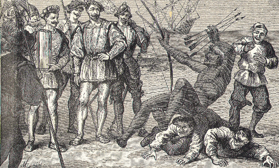